Official Discussion issued by the National Hurricane Center
Franklin (AL082023) DATA RELEASED: 8/31/2023 3:00:00 PM UTC
|
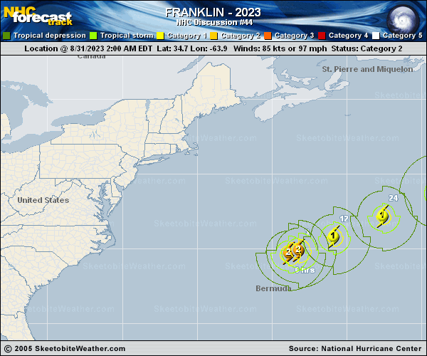
Copy of official data Hurricane Franklin Discussion Number 44 NWS National Hurricane Center Miami FL AL082023 1100 AM AST Thu Aug 31 2023 Satellite imagery indicates that Franklin continues to battle strong northerly shear associated with the outflow from Idalia. Recent microwave data confirm its inner core has eroded, with deep convection confined to the southeastern portion of the circulation. There is a large spread in the recent intensity estimates, with higher objective estimates than the consensus T4.5/5.0 Dvorak classifications from SAB and TAFB. Given this uncertainty, the initial intensity is held at 85 kt for this advisory. Some gradual weakening is forecast during the next couple of days while Franklin contends with the negative impacts of deep-layer shear. However, the cyclone is expected to remain at or near hurricane strength while increased baroclinic forcing and interaction with the upper trough support its extratropical transition. The GFS and ECMWF show fronts extending into Franklin's circulation by 48 h, likely signaling completion of this process. Therefore, the NHC forecast shows Franklin becoming a powerful extratropical cyclone in 48 h. Thereafter, further weakening is forecast while the cyclone moves deeper into the mid-latitudes, in agreement with the latest global guidance. Franklin is moving east-northeastward (70/12 kt) within the flow between a deep-layer trough moving off the coast of the northeastern U.S. and eastern Canada and a subtropical ridge to the east. The latest track guidance remains in very good agreement that Franklin will accelerate toward the east-northeast or northeast during the next couple of days. The NHC track forecast in the near term is essentially an update of the previous one and remains close to the TVCN and HCCA aids. Track model solutions diverge beyond day 3 regarding the track and speed of motion for the extratropical cyclone over the northern Atlantic, and in general the latest NHC forecast lies between the consensus aids and ensemble means. FORECAST POSITIONS AND MAX WINDS INIT 31/1500Z 35.1N 61.6W 85 KT 100 MPH 12H 01/0000Z 36.3N 59.3W 75 KT 85 MPH 24H 01/1200Z 37.8N 55.8W 70 KT 80 MPH 36H 02/0000Z 39.7N 51.7W 70 KT 80 MPH 48H 02/1200Z 42.0N 47.2W 65 KT 75 MPH...POST-TROP/EXTRATROP 60H 03/0000Z 44.2N 43.1W 55 KT 65 MPH...POST-TROP/EXTRATROP 72H 03/1200Z 45.9N 39.1W 50 KT 60 MPH...POST-TROP/EXTRATROP 96H 04/1200Z 48.0N 33.0W 45 KT 50 MPH...POST-TROP/EXTRATROP 120H 05/1200Z 50.5N 28.0W 40 KT 45 MPH...POST-TROP/EXTRATROP $$ Forecaster Reinhart |