Official Discussion issued by the National Hurricane Center
Emily (AL072023) DATA RELEASED: 8/21/2023 9:00:00 AM UTC
|
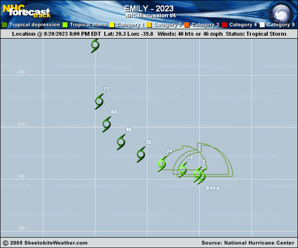
Copy of official data Tropical Storm Emily Discussion Number 4 NWS National Hurricane Center Miami FL AL072023 500 AM AST Mon Aug 21 2023 During the past few hours, Emily has rapidly lost what remained of its deep convection displaced well to the northeast of the exposed surface center. The initial intensity estimate is lowered to 35 kt for this advisory and is supported by the available subjective and objective satellite intensity estimates. The environment surrounding Emily is forecast to become increasingly belligerent by tonight due to deep-layer shear increasing to near 40 kt and a an intruding dry stable air mass. These negatively contributing atmospheric conditions should induce gradual weakening, and Emily should become a post-tropical cyclone by this evening. The initial motion is estimated to be west-northwestward, or 290/10 kt. During the next several days, Emily should maintain a general west-northwestward motion while being steered by a low to mid-tropospheric ridge to the north. By the 48 hour period, a gradual turn northward is expected after Emily degenerates to remnant low, rounding the southern periphery of the aforementioned subtropical ridge. The track guidance is in good agreement on this scenario, and the NHC track forecast is basically an update of the previous advisory. FORECAST POSITIONS AND MAX WINDS INIT 21/0900Z 20.7N 41.1W 35 KT 40 MPH 12H 21/1800Z 21.1N 42.6W 35 KT 40 MPH...POST-TROPICAL 24H 22/0600Z 21.9N 44.6W 30 KT 35 MPH...POST-TROP/REMNT LOW 36H 22/1800Z 22.8N 46.6W 30 KT 35 MPH...POST-TROP/REMNT LOW 48H 23/0600Z 24.2N 48.4W 30 KT 35 MPH...POST-TROP/REMNT LOW 60H 23/1800Z 26.1N 49.4W 25 KT 30 MPH...POST-TROP/REMNT LOW 72H 24/0600Z 28.3N 49.9W 25 KT 30 MPH...POST-TROP/REMNT LOW 96H 25/0600Z 33.6N 50.2W 25 KT 30 MPH...POST-TROP/REMNT LOW 120H 26/0600Z...DISSIPATED $$ Forecaster Roberts |