Official Discussion issued by the National Hurricane Center
Emily (AL072023) DATA RELEASED: 8/20/2023 9:00:00 PM UTC
|
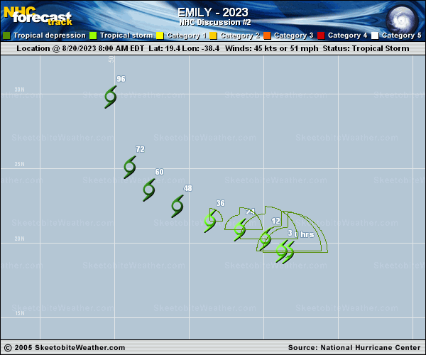
Copy of official data Tropical Storm Emily Discussion Number 2 NWS National Hurricane Center Miami FL AL072023 500 PM AST Sun Aug 20 2023 Emily is feeling the effects of southwesterly vertical wind shear with the low-level center fully exposed to the southwest of the main area of deep convection. The initial intensity is held at 45 kt based on the earlier ASCAT data and the TAFB Dvorak satellite estimate. The environment around Emily is expected to become increasingly hostile the next couple of days with shear increasing to near 40 kt while the system remains in relatively stable air. These unfavorable atmospheric conditions should cause steady weakening, and Emily could become a remnant low in a few of days. The storm is moving to the northwest at 8 kt, and a general west-northwest to northwest motion is expected during the next 2 to 3 days while the storm moves along the southwestern periphery of the ridge. After that time, a turn to the north is forecast while the storm moves around the west side of the ridge and toward a weakness. The new track forecast is similar to the previous one and near the middle of the guidance envelope. FORECAST POSITIONS AND MAX WINDS INIT 20/2100Z 20.2N 39.4W 45 KT 50 MPH 12H 21/0600Z 20.7N 40.7W 40 KT 45 MPH 24H 21/1800Z 21.3N 42.6W 35 KT 40 MPH 36H 22/0600Z 22.1N 44.7W 30 KT 35 MPH 48H 22/1800Z 23.1N 46.7W 30 KT 35 MPH...POST-TROP/REMNT LOW 60H 23/0600Z 24.5N 48.5W 30 KT 35 MPH...POST-TROP/REMNT LOW 72H 23/1800Z 26.4N 49.4W 30 KT 35 MPH...POST-TROP/REMNT LOW 96H 24/1800Z 31.2N 50.0W 30 KT 35 MPH...POST-TROP/REMNT LOW 120H 25/1800Z 37.5N 49.1W 25 KT 30 MPH...POST-TROP/REMNT LOW $$ Forecaster Cangialosi |