Official Discussion issued by the National Hurricane Center
Six (AL062023) DATA RELEASED: 8/20/2023 9:00:00 PM UTC
|
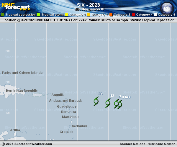
Copy of official data Tropical Depression Six Discussion Number 5 NWS National Hurricane Center Miami FL AL062023 500 PM AST Sun Aug 20 2023 Visible satellite imagery indicates that the deep convection north and east of the depression has dissipated this afternoon. Once again, the center of circulation is completely exposed and is not as well-defined as earlier today. Based on a blend of objective and subjective satellite estimates, the initial intensity estimate for this advisory is held at 30 kt. Not much has changed with the forecast reasoning. Strong deep-layer westerly shear and unfavorable mid-level thermodynamics are expected to preclude further development of the depression. Global models and ensembles are in agreement that intensification is unlikely, and thus the official forecast has the depression as a remnant low in 12 h and dissipated in 24 h. The depression is now moving slightly north of due west, and this general motion is expected to continue until dissipation occurs. The official track forecast is a blend of consensus guidance and is similar to the previous forecast. FORECAST POSITIONS AND MAX WINDS INIT 20/2100Z 16.6N 54.7W 30 KT 35 MPH 12H 21/0600Z 16.7N 56.1W 25 KT 30 MPH...POST-TROP/REMNT LOW 24H 21/1800Z...DISSIPATED $$ Forecaster Hogsett |