Official Discussion issued by the National Hurricane Center
Gert (AL062023) DATA RELEASED: 9/3/2023 9:00:00 AM UTC
|
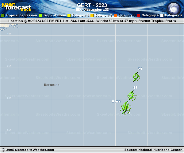
Copy of official data Tropical Storm Gert Discussion Number 22 NWS National Hurricane Center Miami FL AL062023 500 AM AST Sun Sep 03 2023 Gert appears to be maintaining its intensity for the time being, in spite of the presence of strong northeasterly vertical wind shear. The system has been producing a blob of deep convection to the southwest of the estimated center and the low-level circulation is still fairly well defined on GOES-16 proxy-vis imagery. The current intensity is kept at 50 kt for this advisory in agreement with an Advanced Dvorak Technique estimate from UW-CIMSS. The tropical storm is accelerating north-northeastward at a faster forward speed of around 10 kt. A north-northeastward to northward motion with a continued increase in forward speed is likely during the next day or so as Gert becomes entrained into the eastern portion of the much larger circulation of Post-Tropical Cyclone Idalia. Global model guidance shows the system becoming absorbed by Idalia and dissipating in 24 hours or so. The official forecast is similar to that from the previous advisory. FORECAST POSITIONS AND MAX WINDS INIT 03/0900Z 29.9N 52.9W 50 KT 60 MPH 12H 03/1800Z 32.2N 52.0W 50 KT 60 MPH 24H 04/0600Z 36.3N 52.0W 45 KT 50 MPH 36H 04/1800Z...DISSIPATED $$ Forecaster Pasch |