Official Discussion issued by the National Hurricane Center
Gert (AL062023) DATA RELEASED: 9/2/2023 9:00:00 AM UTC
|
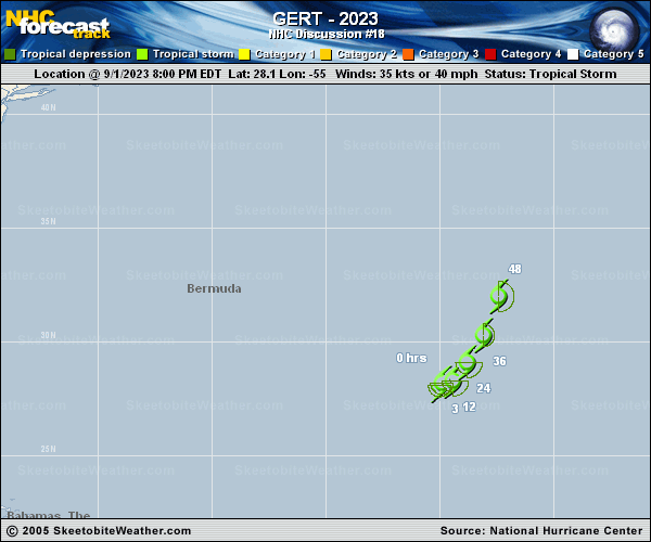
Copy of official data Tropical Storm Gert Discussion Number 18 NWS National Hurricane Center Miami FL AL062023 500 AM AST Sat Sep 02 2023 This morning's conventional satellite imagery and a recent AMSR2 microwave overpass indicate some improvement in the cloud pattern overnight, although Gert's surface center remains near the northern edge of the convective canopy where the colder cloud top temperatures are evident. The subjective and objective satellite intensity estimates have increased a bit during the past 6 hours, and the initial intensity is bumped up to 40 kt for this advisory. Gert's intensity shouldn't change much during the next few days while the cyclone continues moving in a harsh northerly wind shear environment. Gert is forecast to become a post-tropical cyclone during the next couple of days as indicated in the global models fields and their simulated infrared imagery forecasts. Afterwards, Gert is expected to become absorbed by Post-Tropical Idalia. The official intensity forecast follows the IVCN intensity consensus aid through the period and indicates dissipation in 60 hours. Gert should commence a northward track later today while the southerly peripheral steering flow of larger Idalia captures the cyclone and a subtropical ridge builds westward over the central tropical Atlantic. There is quite a bit of along-track spread of the models, however, so the best solution for the NHC forecast track is to side with the consensus models, HCCA and TVCA through dissipation early this week. FORECAST POSITIONS AND MAX WINDS INIT 02/0900Z 27.7N 54.3W 40 KT 45 MPH 12H 02/1800Z 28.0N 53.8W 40 KT 45 MPH 24H 03/0600Z 29.2N 53.1W 40 KT 45 MPH 36H 03/1800Z 30.8N 52.3W 35 KT 40 MPH 48H 04/0600Z 33.4N 51.7W 35 KT 40 MPH...POST-TROPICAL 60H 04/1800Z...DISSIPATED $$ Forecaster Roberts |