Official Discussion issued by the National Hurricane Center
Gert (AL062023) DATA RELEASED: 9/1/2023 9:00:00 PM UTC
|
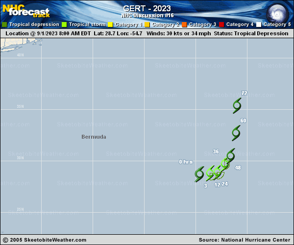
Copy of official data Tropical Storm Gert Discussion Number 16 NWS National Hurricane Center Miami FL AL062023 500 PM AST Fri Sep 01 2023 Gert appears to have strengthened and has become a tropical storm once again. Satellite intensity estimates range from 30 kt (1800 UTC SAB Dvorak Current Intensity) to 46 kt (1701 UTC UW-CIMSS SATCON), so the intensity has been raised to 35 kt in this advisory. AMSR microwave imagery from a few hours ago revealed Gert has a tight well-defined low-level inner-core, and it's possible the 35-kt estimate is conservative. The AMSR pass was also the first clear indication that Gert is centered a little farther south than previously estimated. It's possible that Gert's deep convection, which is limited to the southeast quadrant, is pulling the center slowly in that direction in the absence of other strong steering currents right now. In a couple days, Gert should move a little quicker toward the northeast, steered by a combination of Idalia to its northwest and a low- to mid-level ridge over the eastern and central Atlantic. The NHC track forecast is very close to the multi-model consensus aids TVCN and HCCA, but is a little slower than the previous advisory. Although continued shear should prevent Gert from strengthening much, additional slight intensification is possible today or tomorrow. Most models show the cyclone becoming post-tropical in 48 to 60 hours, and absorbed into the much larger circulation of Idalia soon after. The NHC intensity forecast has been adjusted slightly higher but is still very similar to the previous advisory. One thing to note, the model trackers used to help NHC make track and intensity forecasts appear to be following Idalia at the end of the forecast instead of Gert in many cases. Users should be aware that the tracks and intensities in the NCEP tracker or ATCF files may not be representative of the model depiction of Gert beyond 60-72 h. FORECAST POSITIONS AND MAX WINDS INIT 01/2100Z 27.8N 54.4W 35 KT 40 MPH 12H 02/0600Z 27.7N 53.9W 40 KT 45 MPH 24H 02/1800Z 28.4N 53.2W 40 KT 45 MPH 36H 03/0600Z 29.0N 52.7W 35 KT 40 MPH 48H 03/1800Z 30.6N 51.9W 35 KT 40 MPH 60H 04/0600Z 33.0N 51.2W 35 KT 40 MPH...POST-TROP/EXTRATROP 72H 04/1800Z...DISSIPATED $$ Forecaster D. Zelinsky |