Official Discussion issued by the National Hurricane Center
Bret (AL032023) DATA RELEASED: 6/23/2023 9:00:00 PM UTC
|
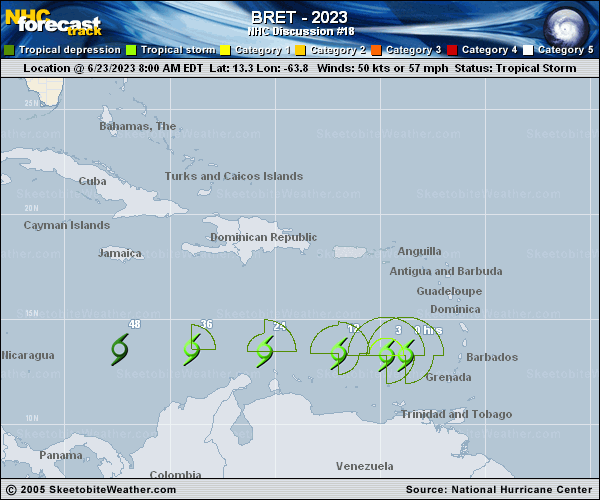
Copy of official data Tropical Storm Bret Discussion Number 18 NWS National Hurricane Center Miami FL AL032023 500 PM AST Fri Jun 23 2023 The intensity of Bret is decreasing as the system moves across the eastern Caribbean Sea. The low-level center is now fully exposed and deep convection is minimal. However, there is a relatively large area of showers well to the east of the center that is lingering over portions of the Lesser Antilles. An ASCAT pass from earlier today showed peak winds between 40-45 kt, and the initial intensity is lowered to 45 kt for this advisory. This estimate is also in agreement with a Dvorak classification from TAFB. Bret is currently experiencing about 20 kt of vertical wind shear, and since the shear is anticipated to increase, continued weakening is expected. All of the models show a steady decline in Bret's strength, and the new forecast is similar to the previous one. Dissipation is expected to occur on Sunday. The tropical storm continues to move quickly westward at 17 kt on the south side of a low- to mid-level ridge. This motion should continue during the next couple of days taking Bret across the eastern and central Caribbean Sea just north of the ABC Islands. The NHC track forecast is again a touch to the south of the previous one and remains on the fast side of the model guidance. FORECAST POSITIONS AND MAX WINDS INIT 23/2100Z 13.1N 66.6W 45 KT 50 MPH 12H 24/0600Z 13.1N 69.1W 40 KT 45 MPH 24H 24/1800Z 13.2N 72.6W 35 KT 40 MPH 36H 25/0600Z 13.2N 76.0W 30 KT 35 MPH 48H 25/1800Z...DISSIPATED $$ Forecaster Cangialosi |