Official Discussion issued by the National Hurricane Center
Bret (AL032023) DATA RELEASED: 6/23/2023 3:00:00 PM UTC
|
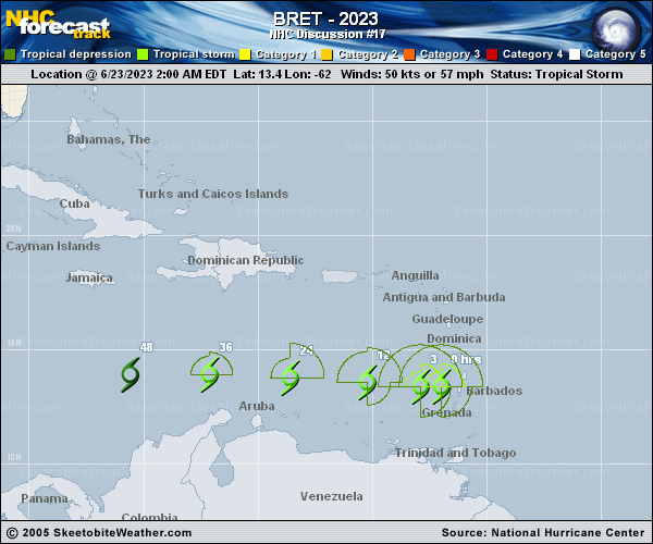
Copy of official data Tropical Storm Bret Discussion Number 17 NWS National Hurricane Center Miami FL AL032023 1100 AM AST Fri Jun 23 2023 Bret is maintaining its intensity for now. Deep convection has increased over the center during the past few hours and there remains a larger area of disorganized thunderstorms on the system's east side. The Air Force Hurricane Hunters have been investigating the storm this morning and on their last pass they found maximum flight-level winds of 60 kt and peak SFMR winds around 45 kt. These data support holding the intensity steady at 50 kt. Bret is pulling away from the Lesser Antilles, but showers and thunderstorms along with gusty winds will likely continue across portions of that island chain for much of the day. Bret is moving beneath an upper-level trough axis currently, but by tonight it should be located on the west side of the trough, which should result in a notable increase in northerly vertical wind shear and intrusions of dry air. Therefore, steady weakening is expected and the NHC intensity forecast follows the theme of the model guidance. Bret will likely open into a trough on Sunday. The tropical storm continues to move quickly westward at 17 kt on the south side of a low- to mid-level ridge. This motion should continue during the next couple of days taking Bret across the eastern and central Caribbean Sea. The NHC track forecast is a touch to the south of the previous one, primarily due to the initial position, and remains on the fast side of the model guidance. KEY MESSAGES: 1. Bret is moving westward over the southeastern Caribbean Sea, but trailing rainbands with embedded gusty winds continue to affect portions of the Windward Islands. These conditions should gradually subside through the day. FORECAST POSITIONS AND MAX WINDS INIT 23/1500Z 13.3N 64.7W 50 KT 60 MPH 12H 24/0000Z 13.4N 67.0W 45 KT 50 MPH 24H 24/1200Z 13.5N 70.5W 40 KT 45 MPH 36H 25/0000Z 13.6N 74.0W 35 KT 40 MPH 48H 25/1200Z 13.6N 77.4W 30 KT 35 MPH 60H 26/0000Z...DISSIPATED $$ Forecaster Cangialosi |