Official Discussion issued by the National Hurricane Center
Bret (AL032023) DATA RELEASED: 6/21/2023 9:00:00 PM UTC
|
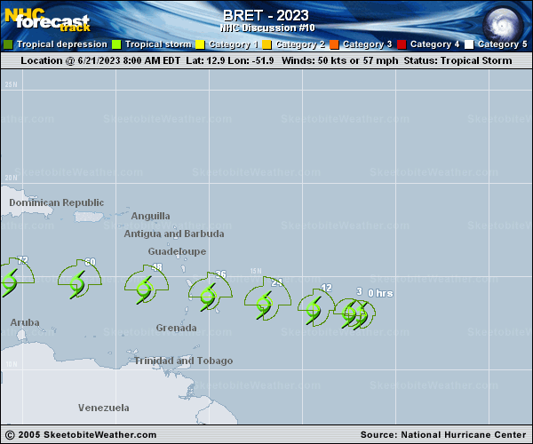
Copy of official data Tropical Storm Bret Discussion Number 10 NWS National Hurricane Center Miami FL AL032023 500 PM AST Wed Jun 21 2023 Despite being under the influence of mid-level westerly shear, Bret appears to have intensified slightly. An Air Force Reserve Hurricane Hunter aircraft measured a fairly solid area of 50- to 55-kt winds to the northeast of the center, and the central pressure has fallen to 1000 mb. In addition, Dvorak estimates from TAFB and SAB are a consensus T3.5/55 kt, so Bret's initial intensity is therefore raised to 55 kt. The deep convection continues to favor the eastern side of the circulation, although a burst of convection recently formed over the center. Although there is a small possibility of slight additional strengthening, continued moderate mid-level shear is likely to keep Bret's intensity hovering around 55 kt for the next 24 hours as it approaches the Lesser Antilles. Most of the intensity guidance supports this scenario. After that time, stronger deep-layer shear is forecast to develop as Bret nears an upper-level trough over the Caribbean Sea, and those conditions are expected to lead to weakening after the cyclone crosses the Lesser Antilles island chain. Global model fields continue to show Bret degenerating into an open trough by Saturday, however a 72-hour forecast point is still shown in this forecast for continuity purposes. Bret continues to move westward, or 280/13 kt, under the influence of low- to mid-level ridging to its north. This steering flow is not expected to change, but Bret is likely to move faster toward the west once it begins weakening in 36 to 48 hours. The track guidance envelope has been stable, and therefore the updated NHC track forecast has been changed very little from the morning forecast. Users are reminded that NHC's track forecasts have average errors of about 45-50 n mi at 36 hours, and there is risk of strong winds and heavy rainfall for several islands within the Lesser Antilles regardless of exactly where the center crosses the island chain. KEY MESSAGES: 1. Bret is forecast to approach the Lesser Antilles through Thursday and then move across those islands late Thursday and Thursday night as a strong tropical storm, bringing a risk of flooding from heavy rainfall, strong winds, and dangerous waves along the coast. 2. Given the uncertainty in the track and intensity forecasts, it is still too early to specify the exact location and magnitude of where Bret's associated hazards could occur. A Tropical Storm Warning is in effect for St. Lucia and Martinique, and a Tropical Storm Watch remains in effect for Barbados and Dominica. Additional warnings are possible for some islands in the Lesser Antilles later tonight. FORECAST POSITIONS AND MAX WINDS INIT 21/2100Z 13.3N 53.9W 55 KT 65 MPH 12H 22/0600Z 13.5N 55.8W 55 KT 65 MPH 24H 22/1800Z 13.8N 58.5W 55 KT 65 MPH 36H 23/0600Z 14.2N 61.7W 50 KT 60 MPH 48H 23/1800Z 14.5N 65.2W 50 KT 60 MPH 60H 24/0600Z 14.7N 68.7W 45 KT 50 MPH 72H 24/1800Z 14.9N 72.2W 40 KT 45 MPH 96H 25/1800Z...DISSIPATED $$ Forecaster Berg |