Official Discussion issued by the National Hurricane Center
Kirk (AL122024) DATA RELEASED: 10/1/2024 9:00:00 PM UTC
|
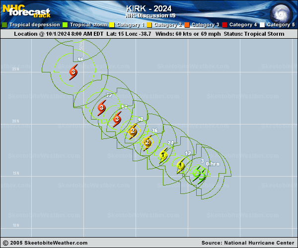
Copy of official data Hurricane Kirk Discussion Number 9 NWS National Hurricane Center Miami FL AL122024 500 PM AST Tue Oct 01 2024 Kirk's appearance on satellite has improved with a large burst of convection near the center and deep convective bands continuing to wrap around the southeast side. A 1808 UTC GPM microwave pass showed an improved inner-core structure with an eyewall noted on the 37 GHz channel. The UW-CIMSS DMINT intensity estimate associated with the microwave image was 63 kt. This estimate combined with the most recent TAFB Dvorak fix of 4.0/65 kt is the basis for making Kirk a hurricane this afternoon with an intensity of 65 kt. Kirk is moving slightly more poleward this afternoon, with an estimated motion of 305/12 kt. This motion, with perhaps a slight slowdown, should continue over the next couple of days as Kirk is primarily steered along the southwestern edge of a subtropical ridge positioned to its north. The western extent of this ridge will become eroded by a long-wave trough offshore of eastern North America towards the latter part of this week, allowing Kirk to turn first northwestward and then recurving north-northeastward by the end of the forecast period. The track guidance continues to be in good agreement, and the latest NHC track forecast lies near the middle of the guidance envelope, very similar to the prior advisory and between the HCCA and TVCN consensus aids. Now that Kirk's inner core is becoming better established it is poised to intensify at a faster rate. Favorable environmental factors surrounding Kirk, such as decreasing shear, warm 28-30 C sea-surface temperatures, and plenty of deep-layer moisture will continue to support a faster rate of strengthening through the 24-48 h period. The NHC intensity forecast shows Kirk becoming a major hurricane towards the end of the forecast period. In addition, Kirk's wind field is forecast to expand as the system moves poleward through the end of the week. Thereafter, hard to predict inner-core structural changes will likely lead to fluctuations in intensity, though by day 5, shear increases again with weakening commencing. However, Kirk will likely remain a large and formidable hurricane through the forecast. The NHC intensity forecast is close the middle of the intensity guidance consensus and still a little on the upper-end towards the end of the forecast period. FORECAST POSITIONS AND MAX WINDS INIT 01/2100Z 16.2N 40.1W 65 KT 75 MPH 12H 02/0600Z 17.1N 41.5W 75 KT 85 MPH 24H 02/1800Z 18.3N 43.1W 85 KT 100 MPH 36H 03/0600Z 19.4N 44.6W 95 KT 110 MPH 48H 03/1800Z 20.4N 46.0W 100 KT 115 MPH 60H 04/0600Z 21.5N 47.6W 105 KT 120 MPH 72H 04/1800Z 22.9N 49.0W 110 KT 125 MPH 96H 05/1800Z 27.0N 51.0W 110 KT 125 MPH 120H 06/1800Z 33.0N 49.0W 95 KT 110 MPH $$ Forecaster Mora/Papin |