Official Discussion issued by the National Hurricane Center
Joyce (AL112024) DATA RELEASED: 9/29/2024 3:00:00 PM UTC
|
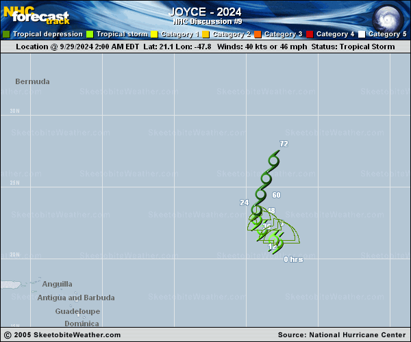
Copy of official data Tropical Storm Joyce Discussion Number 9 NWS National Hurricane Center Miami FL AL112024 1100 AM AST Sun Sep 29 2024 The center of Joyce is exposed on the southern side of a small area of deep convection due to continued strong south-southwesterly vertical wind shear. The most recent scatterometer data from 1230 UTC indicates at least 35 kt winds are within the circulation, and given the known low bias of the instrument, 40 kt is chosen as the initial intensity, closest to a blend of the TAFB T- and CI-numbers. The storm has been moving more slowly this morning, estimated to be northwestward at about 5 kt. Joyce should turn northward on Monday due to a deep-layer trough over the north-central Atlantic. The only notable change to some of the guidance this cycle is that they generally agree Joyce or its remnants will be less vertically deep by mid-week. This evolution should result in less northward acceleration as the circulation decays due to persistent shear and dry air aloft. Thus, the new NHC forecast is a bit to the left and slower based on the latest aids. The intensity guidance remains in good agreement, and the only slight intensity change from the last advisory is to show Joyce becoming a remnant low at 48 h. FORECAST POSITIONS AND MAX WINDS INIT 29/1500Z 21.6N 48.5W 40 KT 45 MPH 12H 30/0000Z 22.1N 49.2W 35 KT 40 MPH 24H 30/1200Z 22.6N 49.3W 30 KT 35 MPH 36H 01/0000Z 23.3N 49.3W 30 KT 35 MPH 48H 01/1200Z 24.1N 49.3W 30 KT 35 MPH...POST-TROP/REMNT LOW 60H 02/0000Z 25.2N 49.3W 25 KT 30 MPH...POST-TROP/REMNT LOW 72H 02/1200Z...DISSIPATED $$ Forecaster Blake |