Official Discussion issued by the National Hurricane Center
Ernesto (AL052024) DATA RELEASED: 8/13/2024 9:00:00 PM UTC
|
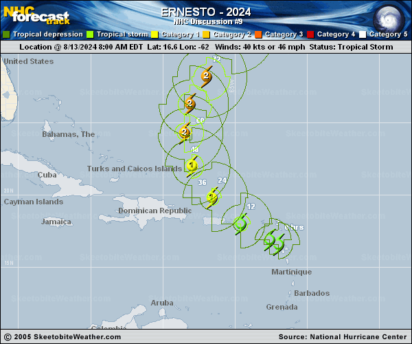
Copy of official data Tropical Storm Ernesto Discussion Number 9 NWS National Hurricane Center Miami FL AL052024 500 PM AST Tue Aug 13 2024 Ernesto's structure continues to gradually increase in organization. There has been some indication of dry air within the circulation and possibly some westerly shear--likely related to the system's continued fast motion--but the maximum winds have been increasing during the day nonetheless. An Air Force Reserve Hurricane Hunter aircraft measured peak 850-mb flight-level winds of 57 kt and believable SFMR winds of 45-50 kt northeast of the center, and dropsonde data showed that the central pressure had fallen to 1001 mb. Based on these data, the initial intensity is set at 50 kt. Some satellite estimates suggest the intensity could be slightly higher, but there will be both Air Force and NOAA aircraft in the storm later this evening to confirm these trends. The recent aircraft fixes indicate that Ernesto continues to turn to the right and is moving west-northwestward, or 300/16 kt. This turn is expected to continue for the next couple of days as Ernesto moves toward a break in the western Atlantic subtropical ridge. On this track, Ernesto's center should pass over the Virgin Islands later this evening and then pass northeast and north of Puerto Rico overnight and on Wednesday. A northward to north-northeastward motion is forecast after 48 hours as Ernesto interacts with a deep-layer trough off the U.S. East Coast, but this trough ends up bypassing Ernesto, resulting in the storm slowing down a bit when it is in the vicinity of Bermuda. The track guidance continues to be very consistent, and again no significant changes were required to the official track forecast compared to the previous issuance. Very warm sea surface temperatures and generally low shear favor continued strengthening over the next few days. SHIPS and the HFIP Corrected Consensus models continue to suggest that Ernesto could reach hurricane strength by 12 hours, and several of the Rapid Intensification (RI) indices are still well above climatology. As a result, the NHC intensity forecast shows Ernesto becoming a hurricane by tonight and then peaking at an intensity at or just below major hurricane strength in 60-72 hours. Since there is some chance of Ernesto becoming a hurricane while it is near the Virgin Islands, a Hurricane Watch remains in effect for the Virgin Islands, Culebra, and Vieques. Key Messages: 1. Tropical storm conditions are expected to continue over portions of the northern Leeward Islands this evening and spread westward to the Virgin Islands and Puerto Rico this evening and tonight. Hurricane conditions are also possible on the Virgin Islands, Culebra, and Vieques this evening and tonight. 2. Heavy rainfall may result in locally considerable flash flooding and mudslides in areas of the Leeward Islands through this evening, and over the Virgin Islands into Puerto Rico by this evening through Wednesday. 3. Ernesto is likely to bring impacts to Bermuda late this week, and interests there should monitor the progress of this system. 4. Swells generated by Ernesto are expected to affect portions of the Virgin Islands, Puerto Rico, the Dominican Republic, the Turks and Caicos, and the Bahamas during the next few days and then reach the east coast of the United States and Bermuda late this week and into the weekend. These swells are likely to cause life-threatening surf and rip current conditions. FORECAST POSITIONS AND MAX WINDS INIT 13/2100Z 18.0N 64.1W 50 KT 60 MPH 12H 14/0600Z 19.3N 65.9W 65 KT 75 MPH 24H 14/1800Z 21.3N 67.6W 75 KT 85 MPH 36H 15/0600Z 23.4N 68.6W 85 KT 100 MPH 48H 15/1800Z 25.4N 68.7W 90 KT 105 MPH 60H 16/0600Z 27.2N 67.9W 95 KT 110 MPH 72H 16/1800Z 29.1N 66.7W 95 KT 110 MPH 96H 17/1800Z 32.7N 65.3W 90 KT 105 MPH 120H 18/1800Z 36.8N 64.1W 90 KT 105 MPH $$ Forecaster Berg |