Official Discussion issued by the National Hurricane Center
Alberto (AL012024) DATA RELEASED: 6/19/2024 4:00:00 PM UTC
|
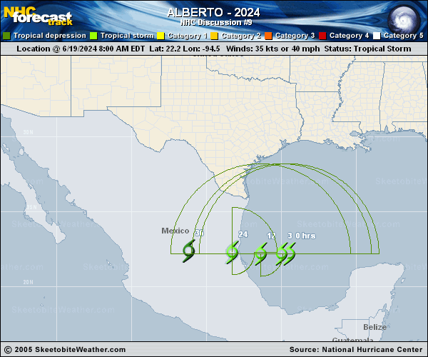
Copy of official data Tropical Storm Alberto Discussion Number 9 NWS National Hurricane Center Miami FL AL012024 400 PM CDT Wed Jun 19 2024 There hasn't been much additional data to help assess the structure of Alberto since the Air Force Reserve reconnaissance aircraft departed the system a few hours ago. However, recent satellite images and data from NOAA buoy 42055 suggest that the center may have re-formed a bit to the southwest since this morning. Another reconnaissance aircraft is scheduled to investigate the system later this evening. For now, the maximum winds remain 35 kt. Because of the re-formation of the center, the recent motion has been west-southwestward, or 250/8 kt. However, Alberto is expected to resume a westward motion and speed up over the next 24 hours as a mid-level ridge over the eastern U.S. builds westward. The track guidance is in good agreement that Alberto's center will reach the coast of Mexico early Thursday, and the NHC track forecast is close to a blend of the TVCA and HCCA models. Some slight strengthening is still possible through tonight while Alberto remains over water, and the NHC intensity forecast continues to show a peak intensity of about 40 kt. The circulation could dissipate over the mountains of Mexico as soon as 24 hours from now, but for continuity a 24-hour forecast is provided with dissipation shown at 36 hours. More importantly, because of Alberto's large size, it will continue to produce heavy rains, moderate coastal flooding, and tropical-storm-force winds across portions of southern Texas and northeastern Mexico regardless of its exact track. It is worth noting that the official wind speed probabilities are likely underestimating the chances of tropical-storm-force winds along the Texas coast because of the unusually large and asymmetric area of strong winds on the northern side of the circulation. Key Messages: 1. Users are reminded not to focus on the exact forecast track of this system. Alberto is very large with rainfall, coastal flooding, and wind impacts occuring far from the center along the coasts of Texas and northeastern Mexico. 2. Heavy rainfall associated with Tropical Storm Alberto will impact large regions of Central America, north across northeastern Mexico and into South Texas. This rainfall will likely produce considerable flash and urban flooding along with new and renewed river flooding. Life-threatening flooding and mudslides are likely in and near areas of higher terrain across the Mexican states of Coahuila, Nuevo Leon, and Tamaulipas, including the cities of Monterrey and Ciudad Victoria. 3. Moderate coastal flooding is likely along much of the Texas Coast through Thursday. 4. Tropical storm conditions are expected today along portions of the Texas coast south of San Luis Pass and along portions of the coast of northeastern Mexico within the Tropical Storm Warning area. FORECAST POSITIONS AND MAX WINDS INIT 19/2100Z 21.9N 95.3W 35 KT 40 MPH 12H 20/0600Z 22.0N 97.0W 40 KT 45 MPH 24H 20/1800Z 22.1N 100.9W 30 KT 35 MPH...INLAND 36H 21/0600Z...DISSIPATED $$ Forecaster Berg |