Official Discussion issued by the National Hurricane Center
Milton (AL142024) DATA RELEASED: 10/7/2024 4:00:00 AM UTC
|
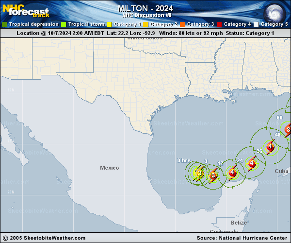
Copy of official data Hurricane Milton Discussion Number 8 NWS National Hurricane Center Miami FL AL142024 400 AM CDT Mon Oct 07 2024 Milton continues to produce a central dense overcast with cloud tops colder than -80C, and since the last advisory a small ragged eye has been present. Satellite intensity estimates have increased to the 80-100 kt range, and based on this the initial intensity is raised to 85 kt. The center has nudged a little southward over the past several hours, and the initial motion is now 105/7 kt. Milton is moving within the southern portion of a broad mid-level trough over the Gulf of Mexico, and is also being influenced by the flow on the southwest side of a low pressure area over the eastern Gulf of Mexico. The global models suggest the mid-level trough and surface low should move eastward into the Atlantic during the next 48 h, with a second mid- to upper-level trough digging into the northwestern Gulf of Mexico. This evolution should cause Milton to move east-southeastward to eastward for the next 36 h or so, followed by a turn toward the northeast at a faster forward speed. The track guidance is in good agreement that the hurricane will cross the Florida Peninsula, but there remains significant differences in both the location and timing of landfall. The UKMET is fastest and farthest to the east, the GFS is slower and much farther north, and the Canadian being the slowest and keeping the storm offshore more than 24 h longer than the other models. The new forecast track calls for the center to reach the Florida west coast between 60-72 h in best agreement with the ECMWF and the multimodel consensus. It should be noted that the average NHC track error at day 3 is around 100 miles, and users should not focus on the exact track. After landfall, Milton should turn more eastward as it becomes extratropical. For the first 36 h or so, Milton should be on an environment of moderate shear over warm sea surface temperatures. Thus, steady to rapid intensification is expected, and the intensity forecast continues to call for the cyclone to become a category 4 hurricane. After 36 h, Milton is expected to encounter a much less favorable environment with strong shear and dry air entrainment. Therefore, some weakening is anticipated before the hurricane reaches the Florida Gulf coast. However, the system is still likely to be a large and powerful hurricane at landfall in Florida, with life-threatening hazards along portions of the the coastline. After landfall, Milton should weaken and start extratropical transition, which should be complete by 96 h. Key Messages: 1. Hurricane conditions are expected across portions of the northern coast of the Yucatan Peninsula. A dangerous storm surge with damaging waves is also likely along portions of the coast of the northern coast of the Yucatan Peninsula. 2. There is an increasing risk of life-threatening storm surge and damaging winds for portions of the west coast of the Florida Peninsula beginning Tuesday night or early Wednesday. Storm Surge and Hurricane Watches are now in effect for portions of the west coast of the Florida Peninsula and residents in that area should follow any advice given by local officials and evacuate if told to do so. 3. Areas of heavy rainfall will impact portions of Florida today well ahead of Milton, with heavy rainfall more directly related to the system expected later on Tuesday through Wednesday night. This rainfall will bring the risk of considerable flash, urban, and areal flooding, along with the potential for moderate to major river flooding. FORECAST POSITIONS AND MAX WINDS INIT 07/0900Z 22.1N 92.6W 85 KT 100 MPH 12H 07/1800Z 21.9N 91.3W 100 KT 115 MPH 24H 08/0600Z 22.2N 89.4W 115 KT 130 MPH 36H 08/1800Z 23.1N 87.5W 125 KT 145 MPH 48H 09/0600Z 24.7N 85.7W 125 KT 145 MPH 60H 09/1800Z 26.4N 83.9W 110 KT 125 MPH 72H 10/0600Z 28.1N 81.7W 75 KT 85 MPH...INLAND 96H 11/0600Z 30.0N 75.5W 55 KT 65 MPH...POST-TROP/EXTRATROP 120H 12/0600Z 31.5N 68.4W 45 KT 50 MPH...POST-TROP/EXTRATROP $$ Forecaster Beven |