Official Discussion issued by the National Hurricane Center
Isaac (AL102024) DATA RELEASED: 9/27/2024 9:00:00 PM UTC
|
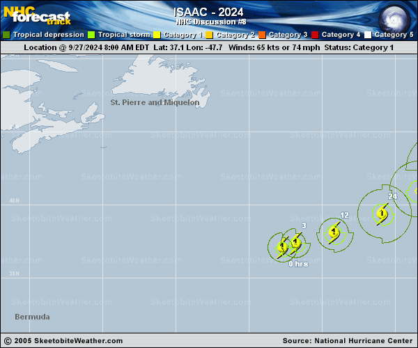
Copy of official data Hurricane Isaac Discussion Number 8 NWS National Hurricane Center Miami FL AL102024 500 PM AST Fri Sep 27 2024 Isaac's satellite presentation has improved since this morning. A small ragged eye can be seen on infrared imagery with cooler cloud tops surrounding it. An AMSR2 microwave pass from earlier today showed the mid- and low-level centers co-located with a primary band in the northwestern quadrant. Both the SAB and TAFB subjective Dvorak classifications suggested that Isaac's intensity has increased. Objective guidance aids are also suggesting the same. Taking all of these into consideration, the intensity has been increased to 75 kt. The hurricane is moving eastward at 14 kt. Isaac is moving in the mid-latitude zonal flow and will gradual turn to the east-northeast later today. In about a day or so, Isaac will begin interacting with an upper-level trough to its east and turn more northeastward and slow down. The latest track forecast is very similar to the previous forecast, however, the day four and five track positions were adjusted westward as the model guidance has been shifting in this direction. Isaac is close to its peak intensity as the window for strengthening is ending soon. By Saturday, it will move over cooler waters, into an area of strong vertical wind shear, and a dry mid-level airmass. The peak intensity has been adjusted upward to 80 kt because of the recent strengthening. On Saturday, Isaac is expect to gradually weaken and this trend will continue for the reminder of the forecast period. Simulated satellite imagery from the global models show Isaac losing its deep convection by Monday and the official forecast now predicts the hurricane to become a post-tropical cyclone by 60 h. FORECAST POSITIONS AND MAX WINDS INIT 27/2100Z 37.8N 45.3W 75 KT 85 MPH 12H 28/0600Z 38.8N 42.7W 80 KT 90 MPH 24H 28/1800Z 40.3N 39.8W 75 KT 85 MPH 36H 29/0600Z 41.8N 37.9W 70 KT 80 MPH 48H 29/1800Z 43.1N 36.3W 65 KT 75 MPH 60H 30/0600Z 44.4N 34.5W 60 KT 70 MPH...POST-TROPICAL 72H 30/1800Z 45.7N 32.7W 50 KT 60 MPH...POST-TROPICAL 96H 01/1800Z 50.1N 29.9W 45 KT 50 MPH...POST-TROP/EXTRATROP 120H 02/1800Z 52.9N 27.3W 35 KT 40 MPH...POST-TROP/EXTRATROP $$ Forecaster Bucci/Rosado |