Official Discussion issued by the National Hurricane Center
Seven (AL072024) DATA RELEASED: 9/13/2024 9:00:00 AM UTC
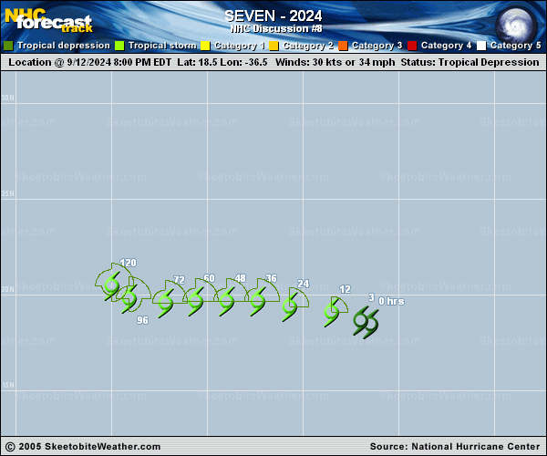
|
Copy of official data Tropical Depression Seven Discussion Number 8 NWS National Hurricane Center Miami FL AL072024 500 AM AST Fri Sep 13 2024 The depression has an asymmetric structure due to moderate west-northwesterly shear, with the center lying west of generally shapeless convective clusters. Because there has largely been little change in the system's organization, and there is quite a range among the subjective and objective estimates, the intensity remains 30 kt out of respect for continuity. The initial motion is a little slower toward the west-northwest (290/12 kt). A weakness in the subtropical ridge to the north of the depression is becoming more pronounced, and the track guidance indicates that the system should turn westward by tonight and slow down further through much of the forecast period as it moves across the central tropical Atlantic. In fact, by days 4 and 5, an amplifying shortwave trough to the north is likely to cause the cyclone to crawl at speeds near or less than 5 kt and gradually turn northwestward. The official forecast is close to the previous prediction during the first 60 hours, but then is adjusted westward on days 3 through 5 following the latest model trends. In terms of moisture, the environment across the tropical Atlantic has not been kind to weather systems over the past couple of months. The official forecast still allows for the possibility of the depression becoming a tropical storm today or tonight, however an even drier air mass to the west is likely to cause the cyclone to continue struggling convectively. In fact, all of the global models show the cyclone's wind field weakening over the weekend, with the GFS suggesting the depression could degenerate into a remnant low. For now, the NHC forecast keeps the system as a tropical cyclone for the entire forecast period, but it does show weakening in a couple of days. Some recovery is possible by days 4 and 5 when the system reaches a slightly more moist and low-shear environment. FORECAST POSITIONS AND MAX WINDS INIT 13/0900Z 19.0N 38.2W 30 KT 35 MPH 12H 13/1800Z 19.4N 39.7W 35 KT 40 MPH 24H 14/0600Z 19.7N 41.6W 35 KT 40 MPH 36H 14/1800Z 19.8N 43.4W 30 KT 35 MPH 48H 15/0600Z 19.7N 45.0W 30 KT 35 MPH 60H 15/1800Z 19.5N 46.7W 30 KT 35 MPH 72H 16/0600Z 19.3N 48.0W 30 KT 35 MPH 96H 17/0600Z 19.2N 49.7W 35 KT 40 MPH 120H 18/0600Z 20.5N 50.6W 40 KT 45 MPH $$ Forecaster Berg |