Official Discussion issued by the National Hurricane Center
Joyce (AL112024) DATA RELEASED: 9/29/2024 3:00:00 AM UTC
|
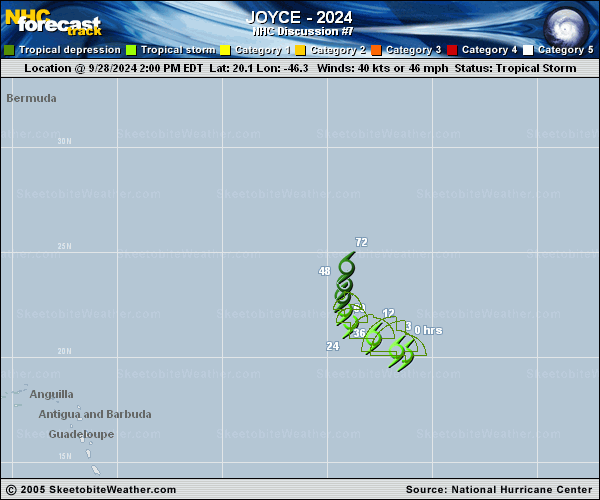
Copy of official data Tropical Storm Joyce Discussion Number 7 NWS National Hurricane Center Miami FL AL112024 1100 PM AST Sat Sep 28 2024 Joyce's low-level center remains exposed on the southwest side of bursting deep convection due to moderate-to-strong south-southwesterly shear. The initial intensity remains 40 kt based on a blend of subjective and objective intensity estimates, and a recent ASCAT-C pass. Deep-layer shear is expected to continue affecting Joyce during the next couple of days, turning more out of the southwest or west, while the storm also moves through a relatively dry air mass. As a result, continued gradual weakening is anticipated, with Joyce potentially becoming a tropical depression by early Monday and a remnant low by early Tuesday. The NHC intensity forecast follows a blend of the HCCA corrected-consensus and the GFS/ECMWF global models. The remnant low is forecast to degenerate into a trough by Wednesday. Joyce has turned northwestward (305 deg) at 8 kt. An amplifying deep-layer trough over the central Atlantic is expected to cause Joyce to turn northward and slow down during the next couple of days. Depending on how much of Joyce is left in 2-3 days, it could accelerate toward the north-northeast ahead of the trough. The NHC track forecast is close to the GFEX consensus aid, and it's a little faster than the previous prediction. FORECAST POSITIONS AND MAX WINDS INIT 29/0300Z 20.9N 47.5W 40 KT 45 MPH 12H 29/1200Z 21.6N 48.5W 35 KT 40 MPH 24H 30/0000Z 22.4N 49.2W 35 KT 40 MPH 36H 30/1200Z 23.1N 49.3W 30 KT 35 MPH 48H 01/0000Z 23.8N 49.2W 30 KT 35 MPH 60H 01/1200Z 24.8N 48.9W 25 KT 30 MPH...POST-TROP/REMNT LOW 72H 02/0000Z 26.2N 48.4W 25 KT 30 MPH...POST-TROP/REMNT LOW 96H 03/0000Z...DISSIPATED $$ Forecaster Berg |