Official Discussion issued by the National Hurricane Center
Isaac (AL102024) DATA RELEASED: 9/27/2024 3:00:00 PM UTC
|
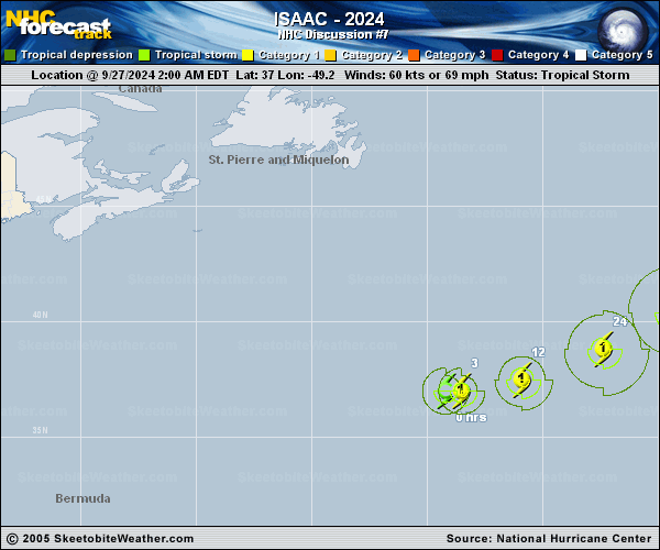
Copy of official data Hurricane Isaac Discussion Number 7 NWS National Hurricane Center Miami FL AL102024 1100 AM AST Fri Sep 27 2024 Isaac is holding steady this morning. Geostationary satellite data has shown consistent periodic bursts of convection wrapping around a small eye. Subjective and objective Dvorak estimates range widely from 35 kt to 73 kt and the initial intensity is held at 65 kt for this advisory, closest to the SAB classification. The hurricane is moving eastward at 12 kt. Isaac is moving along the northern periphery of a mid-level ridge and should gradually turn to the east-northeast over the next couple of days. Models are more in agreement this cycle and show a more northeastward turn on days 4 and 5 as Isaac interacts with an upper-level trough located to its east. The latest track forecast is similar to the previous forecast through 72 h and slightly to the north at forecast periods beyond. Isaac could still strengthen further over the next day or so. While the vertical wind shear is expected to be strong-to-moderate, the upper-level divergence is forecast to increase and sea surface temperature should be relatively sufficient. Beyond a day or so, oceanic and environmental conditions become less conducive, which should begin to weaken Isaac by Saturday night or Sunday. The official intensity forecast is very similar to previous advisory, with a peak intensity of 75 kt by Saturday and the cyclone becoming extratropical by early next week. However, global models show the system losing its deep convection by Monday, and the official forecast now predicts Isaac becoming a post-tropical cyclone at that point. FORECAST POSITIONS AND MAX WINDS INIT 27/1500Z 37.4N 46.8W 65 KT 75 MPH 12H 28/0000Z 38.1N 44.2W 70 KT 80 MPH 24H 28/1200Z 39.4N 40.9W 75 KT 85 MPH 36H 29/0000Z 41.0N 38.4W 75 KT 85 MPH 48H 29/1200Z 42.4N 36.6W 70 KT 80 MPH 60H 30/0000Z 43.7N 35.1W 60 KT 70 MPH 72H 30/1200Z 44.8N 33.0W 55 KT 65 MPH...POST-TROPICAL 96H 01/1200Z 48.0N 29.6W 45 KT 50 MPH...POST-TROP/EXTRATROP 120H 02/1200Z 52.1N 25.0W 35 KT 40 MPH...POST-TROP/EXTRATROP $$ Forecaster Bucci |