Official Discussion issued by the National Hurricane Center
(AL012024) DATA RELEASED: 6/19/2024 4:00:00 AM UTC
|
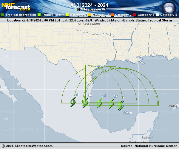
Copy of official data Potential Tropical Cyclone One Discussion Number 7 NWS National Hurricane Center Miami FL AL012024 400 AM CDT Wed Jun 19 2024 Dropsonde observations from an Air Force Reserve Unit Hurricane Hunter aircraft indicate that the circulation of the system is gradually becoming better defined. However, the central convection remains rather meager and the system's cloud pattern is still not classifiable via the Dvorak technique. Therefore the disturbance still does not meet the requirements of a tropical cyclone and will continue to be designated as a potential tropical cyclone at this time. Nonetheless, since the system appears to be on its way to developing a well-defined center, it is expected to become a tropical cyclone later today. This also suggested by simulated satellite imagery from the ECMWF and GFS models that depict increasing and organized deep convection near the center as it nears the coastline. The system is turning westward and the current motion is around 285/7 kt. A mid-level ridge extending west-southwestward from a strong high over the eastern United States should force the disturbance to move on a westward path with increasing forward speed. The track model guidance and model consensus are in good agreement on this scenario, and the official forecast is similar to the previous NHC track, albeit a bit faster. The current intensity estimate remains at 35 kt based on non-elevated surface observations over the Gulf. Environmental conditions, such as warm SSTs and low vertical shear, appear to favor some intensification before landfall. However, the inner circulation is likely to remain somewhat broad, limiting strengthening. The official intensity forecast is the same as the previous one and in good agreement with the statistical-dynamical Decay-SHIPS guidance. Regardless of the exact track of the low, this system will have a large area of heavy rains, moderate coastal flooding and tropical-storm-force winds well north of the center. Importantly, the official wind speed probabilities are likely underestimating the chances of tropical-storm-force winds along the Texas coast because of the unusually large and asymmetric area of strong winds on the northern side of the circulation. Key Messages: 1. Users are reminded not to focus on the exact forecast track of this system. The disturbance is very large with rainfall, coastal flooding, and wind impacts likely to occur far from the center along the coasts of Texas and northeastern Mexico. 2. Rainfall associated with Potential Tropical Cyclone One will impact large regions of Central America, north across northeastern Mexico and into South Texas. This rainfall will likely produce considerable flash and urban flooding along with new and renewed river flooding. Life-threatening flooding and mudslides are likely in and near areas of higher terrain across the Mexican states of Coahuila, Nuevo Leon, and Tamaulipas, including the cities of Monterrey and Ciudad Victoria. 3. Moderate coastal flooding is likely along much of the Texas Coast through midweek. 4. Tropical storm conditions are expected today along portions of the Texas coast south of San Luis Pass and along portions of the coast of northeastern Mexico within the Tropical Storm Warning area. FORECAST POSITIONS AND MAX WINDS INIT 19/0900Z 22.7N 93.8W 35 KT 40 MPH...POTENTIAL TROP CYCLONE 12H 19/1800Z 22.7N 95.0W 40 KT 45 MPH...TROPICAL CYCLONE 24H 20/0600Z 22.7N 97.2W 40 KT 45 MPH...TROPICAL CYCLONE 36H 20/1800Z 22.7N 100.0W 25 KT 30 MPH...INLAND 48H 21/0600Z...DISSIPATED $$ Forecaster Pasch |