Official Discussion issued by the National Hurricane Center
Joyce (AL112024) DATA RELEASED: 9/28/2024 9:00:00 PM UTC
|
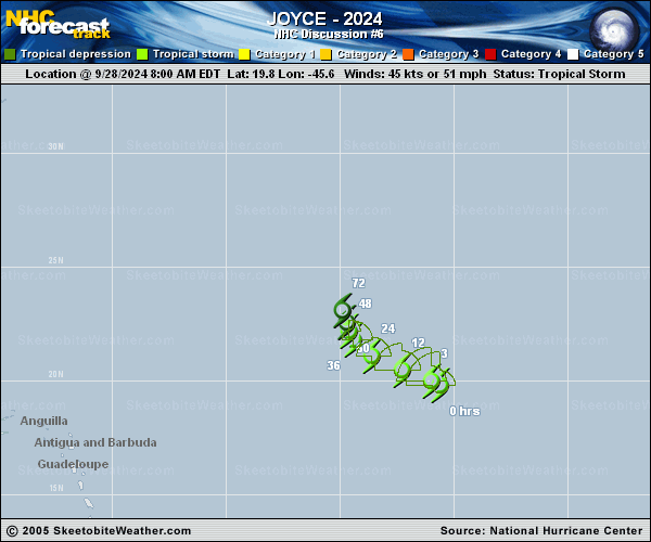
Copy of official data Tropical Storm Joyce Discussion Number 6 NWS National Hurricane Center Miami FL AL112024 500 PM AST Sat Sep 28 2024 Joyce is still feeling the effects of the southerly deep-layer wind shear. Periodic bursts of convection have been forming just north of the center and quickly moving poleward, leaving the low-level circulation partially exposed all afternoon. Objective and subjective satellite intensity estimates have been coming down, and the initial intensity has been lowered to 40 kt for this advisory. Dry mid-level humidities and moderate-to-strong vertical wind shear should induce gradual weakening over the next few days. Joyce is expected to become a tropical depression on Monday, a post-tropical remnant low on Tuesday, and dissipated on Wednesday. The official intensity forecast has been adjusted downward slightly due to the lower initial intensity. The motion of the storm is now west-northwestward at 8 kt. A west-northwestward to northwestward motion, with a slower forward speed is expected for the next day or so as Joyce is steered by a narrow subtropical ridge to the north. On Monday, Joyce should turn more north-northwestward to northward towards a weakens in the ridge caused by a deepening trough over the northern Atlantic. More of the model guidance is showing Joyce, or its remnants, being picked up by the trough and the track guidance envelope has shifted north and east. The latest NHC track forecast has shifted north and east of the previous prediction and lies on the western side of the various consensus aids. FORECAST POSITIONS AND MAX WINDS INIT 28/2100Z 20.3N 46.7W 40 KT 45 MPH 12H 29/0600Z 20.9N 47.8W 40 KT 45 MPH 24H 29/1800Z 21.7N 48.9W 35 KT 40 MPH 36H 30/0600Z 22.3N 49.2W 35 KT 40 MPH 48H 30/1800Z 22.9N 49.3W 30 KT 35 MPH 60H 01/0600Z 23.5N 49.2W 30 KT 35 MPH 72H 01/1800Z 24.3N 49.1W 25 KT 30 MPH...POST-TROP/REMNT LOW 96H 02/1800Z...DISSIPATED $$ Forecaster Bucci |