Official Discussion issued by the National Hurricane Center
Ernesto (AL052024) DATA RELEASED: 8/13/2024 3:00:00 AM UTC
|
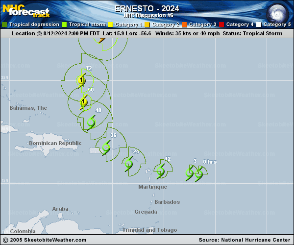
Copy of official data Tropical Storm Ernesto Discussion Number 6 NWS National Hurricane Center Miami FL AL052024 1100 PM AST Mon Aug 12 2024 Ernesto remains a rather broad tropical cyclone, and satellite and radar data shows that deep convection has yet to consolidate/concentrate near its center. Tonight's NOAA P-3 TDR data in Ernesto also suggests the broad center currently lacks much vertical alignment. However, there are a number of convective banding features around the circulation and the overall organization of the cloud pattern has been increasing since earlier today. Satellite imagery shows that the upper-level anticyclonic outflow pattern is well defined over the western semicircle of the circulation. The intensity is held at 35 kt for this advisory based on observations from Air Force and NOAA reconnaissance aircraft and Dvorak satellite estimates. Since the system is still in the formative stage, there is some scatter in the center position estimates, making the initial motion estimate somewhat uncertain. My best motion estimate is generally westward at a slightly slower speed, around 275/22 kt. During the next day or so, a mid-level ridge to the north of Ernesto should maintain a westward to west-northwestward motion at a gradually decreasing forward speed. This should take the center of the tropical cyclone over portions of the Leeward Islands very soon, across the extreme northeastern Caribbean Sea on Tuesday, and near or over portions of Puerto Rico Tuesday evening or Tuesday night. After that, the flow on the eastern side a deep-layer trough moving off the U.S. east coast should cause Ernesto turn northward to north-northeastward. Later in the forecast period, the first trough that steers the system northward from the Greater Antilles leaves Ernesto behind, and the tropical cyclone may have to wait for a second trough to steer it farther into the mid-latitudes. The official track forecast is near the left edge of the guidance suite during the first 24-36 hours and close to the simple model consensus from 2-5 days. Assuming that deep convection will increase near the center of Ernesto, the high-level outflow and otherwise conducive oceanic and atmospheric environment favors strengthening during the next few days. Although the intensification is expected to be gradual during the early part of the period, a more rapid rate of strengthening is likely after the system moves north of the Greater Antilles. The official intensity forecast is about the same as the previous one and close to the multi-model consensus. Key Messages: 1. Ernesto is expected to bring tropical storm conditions to portions of the Leeward Islands beginning early Tuesday and to the Virgin Islands and Puerto Rico by late Tuesday. Tropical Storm Warnings are in effect for this entire area. 2. Heavy rainfall may result in locally considerable flash flooding and mudslides in areas of the Leeward and Virgin Islands through Wednesday, and over Puerto Rico late Tuesday into Thursday. 3. It is too soon to know what impacts Ernesto could bring to Bermuda late this week, and interests there should monitor the progress of this system. FORECAST POSITIONS AND MAX WINDS INIT 13/0300Z 16.0N 59.6W 35 KT 40 MPH 12H 13/1200Z 16.4N 62.0W 40 KT 45 MPH 24H 14/0000Z 17.7N 64.6W 50 KT 60 MPH 36H 14/1200Z 19.5N 66.5W 60 KT 70 MPH 48H 15/0000Z 21.7N 67.8W 70 KT 80 MPH 60H 15/1200Z 24.0N 68.3W 80 KT 90 MPH 72H 16/0000Z 26.1N 67.7W 90 KT 105 MPH 96H 17/0000Z 29.9N 65.3W 95 KT 110 MPH 120H 18/0000Z 32.7N 64.2W 95 KT 110 MPH $$ Forecaster Pasch |