Official Discussion issued by the National Hurricane Center
Beryl (AL022024) DATA RELEASED: 6/30/2024 3:00:00 AM UTC
|
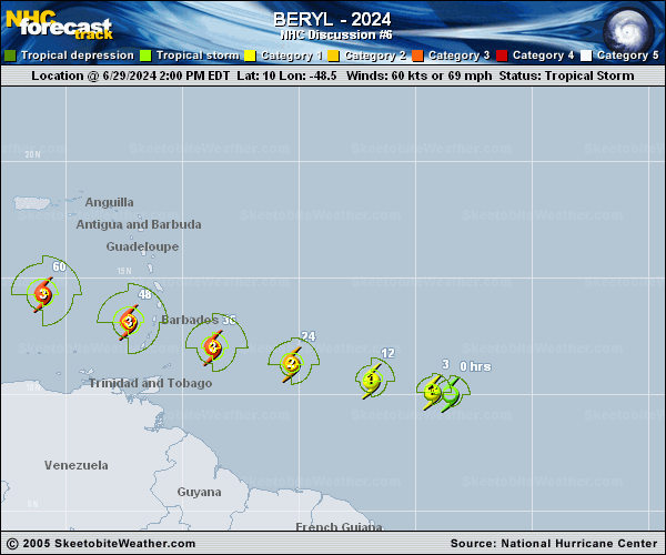
Copy of official data Hurricane Beryl Discussion Number 6 NWS National Hurricane Center Miami FL AL022024 1100 PM AST Sat Jun 29 2024 Beryl continues to strengthen rapidly this evening. Cold convective cloud tops between -70 to -80 C are now wrapping fully around the center after earlier being confined to its southern semicircle. After the prior advisory, a late arriving SSMIS microwave pass revealed a small closed eyewall now exists. The latest subjective and objective intensity estimates range between 65 to 80 kt and based on the continued improved structure on satellite imagery, the intensity is set at 75 kt, towards the upper end of those estimates. As earlier mentioned, both the NOAA and Air Force Reserve Hurricane Hunters will investigate Beryl tomorrow morning, which will provide our first in-situ data to assess the hurricane. Beryl has maintained a just north of due west fast motion this evening, estimated at 280/17 kt. An extensive mid-level ridge remains positioned poleward of the hurricane, and Beryl should maintain a westward to west-northwestward motion at a similar speed over the next couple of days. This track will take the hurricane over the Windward Islands overnight on Sunday into Monday. A subtle weakness in this ridging in the 24-48 hour period should help the hurricane gain a bit of latitude before the ridge builds back in over the southeastern U.S. by the middle of next week, likely resulting in a turn back more westward by the end of the forecast period. The NHC forecast track is just a touch left and slower compared to the prior advisory, but remains very close to a blend of the consensus aids HCCA and TVCN. Unfortunately Beryl has all the ingredients favorable for continued rapid intensification in the short-term. The light to moderate easterly shear that had been affecting the system is subsiding, while the hurricane remains embedded in a large area of deep-layer moisture and over 28-29 C sea-surface temperatures. The small and well-organized inner core likely means the hurricane should take full advantage of these pristine conditions, and both the GFS and ECMWF versions of SHIPS-RII show rapid intensification indices 7 to 10 times above climatology. Thus, the latest NHC intensity forecast will explicitly show rapid intensification over the next day, making Beryl a very dangerous Category 3 hurricane before it moves across the Windward islands by tomorrow night. Once Beryl enters the Caribbean, there could be a marked increase in westerly vertical wind shear as a strong easterly low-level jet, common for this time of year in the eastern Caribbean Sea, will keep Beryl moving quickly westward against lighter upper-level upper-level easterlies partially eroded by a deep-layer trough off the Eastern Seaboard. Thus some weakening is forecast after 48 hours as Beryl moves further into the Caribbean. The NHC intensity forecast remains close to the reliable consensus aids and now shows a peak intensity of 110 kt in 36 hours, though a few of the regional-hurricane models do peak Beryl stronger than shown here. Key Messages: 1. Beryl is expected to be a dangerous major hurricane when it reaches the Windward Islands late Sunday night or Monday, bringing destructive hurricane-force winds and life-threatening storm surge. Hurricane Warnings are in effect for much of the Windward Islands. 2. Heavy rainfall and localized flooding is expected across the Windward Islands Sunday night and Monday. 3. Interests in the central and western Caribbean should monitor the progress of this system. Users are reminded that there is large uncertainty at days 4 and 5 and to not focus on the specific details of the track or intensity forecast. FORECAST POSITIONS AND MAX WINDS INIT 30/0300Z 10.4N 51.2W 75 KT 85 MPH 12H 30/1200Z 10.8N 53.7W 90 KT 105 MPH 24H 01/0000Z 11.5N 57.0W 105 KT 120 MPH 36H 01/1200Z 12.3N 60.4W 110 KT 125 MPH 48H 02/0000Z 13.4N 64.0W 110 KT 125 MPH 60H 02/1200Z 14.6N 67.6W 105 KT 120 MPH 72H 03/0000Z 15.6N 71.7W 100 KT 115 MPH 96H 04/0000Z 17.0N 78.9W 85 KT 100 MPH 120H 05/0000Z 18.5N 85.0W 75 KT 85 MPH $$ Forecaster Papin |