Official Discussion issued by the National Hurricane Center
Leslie (AL132024) DATA RELEASED: 10/3/2024 3:00:00 PM UTC
|
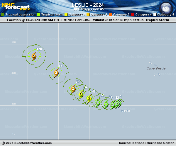
Copy of official data Tropical Storm Leslie Discussion Number 5 NWS National Hurricane Center Miami FL AL132024 1100 AM AST Thu Oct 03 2024 Leslie is becoming better organized this morning. An earlier microwave pass depicted a more well-defined center with better defined curved banding features. Recent satellite-derived wind data depicts max winds around 38-40 kt. Subjective and objective Dvorak satellite intensity estimates range from 35-40 kt. Given the improved organizational structure and satellite trends will lean towards the higher end of these estimates with an initial intensity of 40 kt. The tropical storm is moving slowly westward at an estimated motion of 260/4 kt to the south of a subtropical ridge over the eastern Atlantic. As we move into Friday and this weekend the system will gradually turn west-northwestward then northwestward increasing its forward speed rounding the subtropical ridge. Model guidance is tightly clustered and in fairly good agreement. The NHC track forecast is very near the previous, and lies near the simple and corrected consensus aids. The system is still feeling some of the effects of the outflow of Kirk, however as Kirk begins to move further away shear is forecast to weaken. The oceanic and atmospheric environmental conditions are conducive for steady strengthening with warm sea surface temperature and plenty of moisture. The NHC intensity forecast lies near the upper-end of the guidance envelope given the improved structure and favorable environment, and lies near the HCCA corrected consensus. Towards the end of the forecast period the intensity forecast plateaus given the system is forecast to track behind the cold wake of Hurricane Kirk. FORECAST POSITIONS AND MAX WINDS INIT 03/1500Z 10.1N 30.8W 40 KT 45 MPH 12H 04/0000Z 10.1N 31.5W 50 KT 60 MPH 24H 04/1200Z 10.4N 32.8W 60 KT 70 MPH 36H 05/0000Z 10.8N 34.2W 70 KT 80 MPH 48H 05/1200Z 11.4N 35.7W 75 KT 85 MPH 60H 06/0000Z 12.3N 37.0W 80 KT 90 MPH 72H 06/1200Z 13.3N 38.2W 85 KT 100 MPH 96H 07/1200Z 15.9N 41.1W 90 KT 105 MPH 120H 08/1200Z 18.6N 44.6W 95 KT 110 MPH $$ Forecaster Kelly/E.Adams |