Official Discussion issued by the National Hurricane Center
Joyce (AL112024) DATA RELEASED: 9/28/2024 3:00:00 PM UTC
|
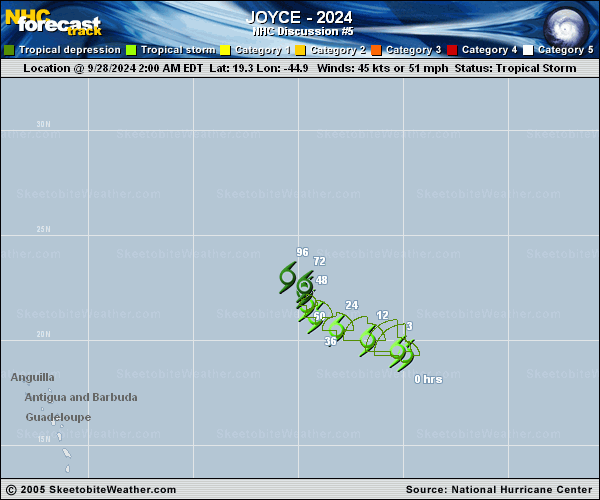
Copy of official data Tropical Storm Joyce Discussion Number 5 NWS National Hurricane Center Miami FL AL112024 1100 AM AST Sat Sep 28 2024 Joyce seems to be experiencing the effects of moderate-to-strong vertical wind shear. After maintaining a decent convective burst overnight, southerly wind shear appears to be pulling the thunderstorms to the north, partially exposing the low-level circulation. A new burst of convection is now growing near the center. Satellite-derived surface wind data measured a few wind speeds greater than 40 kt in the northwest quadrant, and the initial intensity is held at 45 kt for this advisory. The storm continues to move at 305/9 kt. Joyce is on the south side of a narrow and weakening subtropical ridge, and should continue generally west-northwestward to northwestward for the next day or so. As a deep-layer trough over the northern Atlantic amplifies and breaks the ridge, Joyce should slow and turn more poleward early next week. The official forecast still shows the storm not recurving to the north, as it is expected to be a shallow vortex at that time, and instead drifts north-northwestward until the system dissipates, similar to the previous prediction. Atmospheric conditions are forecast to remain marginal around Joyce in the coming days. The SHIPS model diagnostics show the deep-layer vertical wind shear staying moderate-to-strong, likely forcing dry air into Joyce's circulation. The latest intensity forecast is similar to the previous advisory and calls for little change in intensity today, followed by steady weakening through early next week. Joyce is still expected to become a remnant low by day 3, however, models are now showing the system opening into a trough and dissipating by day 4, and this is reflected in the official forecast. FORECAST POSITIONS AND MAX WINDS INIT 28/1500Z 20.0N 46.0W 45 KT 50 MPH 12H 29/0000Z 20.5N 47.3W 45 KT 50 MPH 24H 29/1200Z 21.1N 48.6W 40 KT 45 MPH 36H 30/0000Z 21.8N 49.4W 40 KT 45 MPH 48H 30/1200Z 22.2N 49.6W 35 KT 40 MPH 60H 01/0000Z 22.6N 49.7W 30 KT 35 MPH 72H 01/1200Z 23.1N 49.9W 25 KT 30 MPH...POST-TROP/REMNT LOW 96H 02/1200Z...DISSIPATED $$ Forecaster Bucci |