Official Discussion issued by the National Hurricane Center
Francine (AL062024) DATA RELEASED: 9/9/2024 4:00:00 PM UTC
|
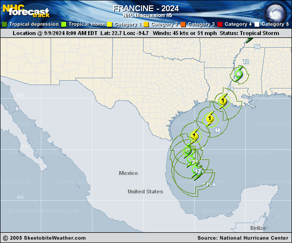
Copy of official data Tropical Storm Francine Discussion Number 5 NWS National Hurricane Center Miami FL AL062024 400 PM CDT Mon Sep 09 2024 Since the prior advisory, Francine's structure has continued to improve. Curved bands are becoming more obvious on geostationary satellite imagery, even if the coldest cloud tops have warmed from earlier today. The last Air Force reconnaissance mission into Francine on its final center fix found a formative inner-core with a partial eyewall, 850 mb flight level winds up to 58 kt, and pressure down to 996 mb, a significant drop from this morning. These data were the basis for bringing the 18 UTC intensity up to 50 kt. Since then, a mid-level eye feature on the Brownsville radar has become apparent. Assuming some additional deepening, the initial intensity is set to 55 kt for this advisory. With the center becoming better established, the motion is a bit easier to estimate, currently at 340/6 kt. While the system has reformed a bit west of the previous track, the overall thinking has not changed much, as Francine will be moving around the periphery of a mid-level ridge centered over Cuba, and an upper-level trough propagating into Texas. This trough will ultimately shift the track of a more vertically deep Francine northeastward tomorrow with gradual acceleration until the storm makes landfall sometime between 48 to 60 h. The track guidance this cycle has shifted westward, likely due to the more westward initial position, and is also a little faster. The latest NHC track forecast follows suit, showing a shift to the west and a faster motion, blending the prior forecast towards the reliable consensus aids TCVN and HCCA. With the forming inner-core earlier observed by recon and still seen on radar currently, the tropical storm appears poised to intensify more significantly in the short term. Given the low vertical wind shear, ample moisture, and very warm sea-surface temperatures, a faster rate of intensification is shown over the next 36 h, and Francine is now forecast to become a hurricane tonight or tomorrow morning, and a Category 2 hurricane by Wednesday. In the final 12-18 h before landfall, shear is expected to increase markedly, which will likely halt the intensification, though Francine is expected to be a Category 2 hurricane at landfall. Rapid weakening is expected after the system moves inland. The NHC intensity forecast is on the upper-end of the overall intensity guidance, but still is lower than some of the hurricane-regional model guidance (HAFS-B, HMON). Given the changes to the forecast, Hurricane and Storm Surge Warnings have been issued for a significant portion of the Louisiana coastline. An experimental cone graphic that includes inland Hurricane and Tropical Storm Watches and Warnings in the U.S. is now available on the NHC website. Due to the time needed to compile the inland watch and warning information, the experimental cone graphic will not be available as quickly as the operational cone. Once it is available, the experimental cone graphic can be found from a red weblink above the operational cone graphic at https://www.nhc.noaa.gov/graphics_at1.shtml?cone#contents. Users are encouraged to take the experimental product survey found below the experimental cone. KEY MESSAGES: 1. Francine is expected to be a hurricane when it reaches the coast of Louisiana on Wednesday, and there is a danger of life-threatening storm surge for portions of the Upper Texas and Louisiana coastlines where a Storm Surge Warning is now in effect. Residents in the warning area should follow advice, including evacuation orders, given by local officials. 2. Damaging and life-threatening hurricane-force winds are expected in portions of southern Louisiana Wednesday, where a Hurricane Warning is now in effect. Preparations to protect life and property should be complete by Tuesday night since tropical storm conditions are expected to begin within this area early Wednesday. 3. Francine is expected to bring heavy rainfall and the risk of considerable flash flooding along the coast of northeast Mexico, the far lower and far upper Texas coasts, southern Louisiana, and southern Mississippi into Thursday morning. A risk of flash and urban flooding exists across portions of the Mid-South from Wednesday into Friday morning. FORECAST POSITIONS AND MAX WINDS INIT 09/2100Z 24.0N 96.0W 55 KT 65 MPH 12H 10/0600Z 24.8N 96.4W 65 KT 75 MPH 24H 10/1800Z 25.9N 95.9W 75 KT 85 MPH 36H 11/0600Z 27.4N 94.7W 85 KT 100 MPH 48H 11/1800Z 29.4N 92.8W 85 KT 100 MPH 60H 12/0600Z 31.8N 91.3W 45 KT 50 MPH...INLAND 72H 12/1800Z 34.2N 90.8W 30 KT 35 MPH...INLAND 96H 13/1800Z 36.9N 90.3W 25 KT 30 MPH...POST-TROPICAL 120H 14/1800Z 38.2N 89.1W 20 KT 25 MPH...POST-TROPICAL $$ Forecaster Papin |