Official Discussion issued by the National Hurricane Center
(AL022024) DATA RELEASED: 7/9/2024 10:00:00 PM UTC
|
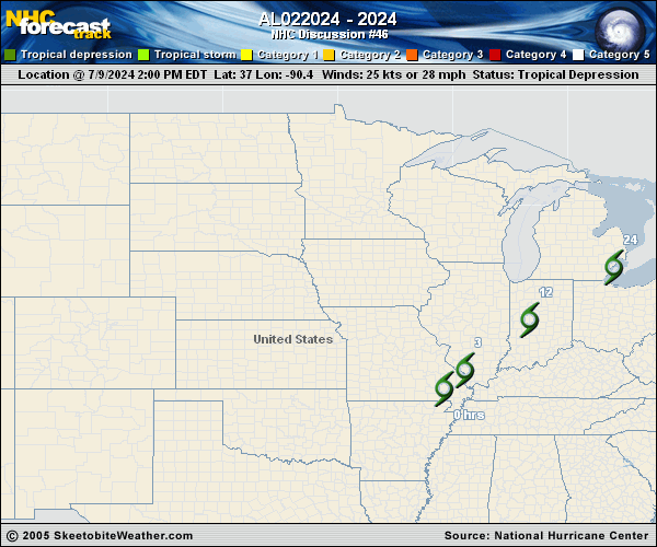
Copy of official data Post-Tropical Cyclone Beryl Discussion Number 46 NWS Weather Prediction Center College Park MD AL022024 1000 PM CDT Tue Jul 09 2024 Key Messages: 1. Heavy rainfall will result in scattered flash flooding through tonight from portions of the Mid Mississippi Valley into the Great Lakes. The rainfall and flash flood risk will move into portions of northern New York and northern New England on Wednesday. 2. A couple of tornadoes remain possible across parts of the Ohio Valley this evening and tonight. FORECAST POSITIONS AND MAX WINDS INIT 10/0300Z 39.6N 86.5W 25 KT 30 MPH...POST-TROPICAL 12H 10/1200Z 41.4N 83.5W 25 KT 30 MPH...POST-TROP/INLAND 24H 11/0000Z 43.6N 79.7W 25 KT 30 MPH...POST-TROP/INLAND 36H 11/1200Z 45.3N 76.5W 20 KT 25 MPH...POST-TROP/INLAND 48H 12/0000Z 47.3N 73.0W 20 KT 25 MPH...POST-TROP/INLAND 60H 12/1200Z...DISSIPATED $$ Forecaster Bann |