Official Discussion issued by the National Hurricane Center
Beryl (AL022024) DATA RELEASED: 7/8/2024 4:00:00 PM UTC
|
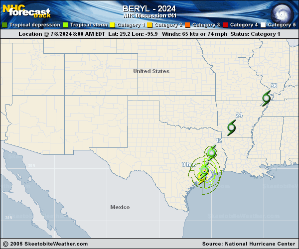
Copy of official data Tropical Storm Beryl Discussion Number 41 NWS National Hurricane Center Miami FL AL022024 400 PM CDT Mon Jul 08 2024 Beryl continues to weaken. Satellite images show that the low- and mid-level centers have decoupled, and NWS Doppler wind velocities are decreasing. The initial wind speed is set to 40 kt, in accordance with radar data and surface observations. Beryl should gradually lose strength and is expected to become a tropical depression tonight or overnight. The intensity forecast is about the same as the last one, except a little stronger in the post-tropical phase near the Great Lakes due to recent global model wind forecasts of some extratropical energy keeping the winds more stead at long range. The storm is moving north-northeastward, faster at 14 kt. Beryl should turn northeastward overnight and accelerate across the lower Mississippi Valley into the Ohio Valley during the next couple of days until dissipation occurs between 72-96 h. The new forecast track is similar to the previous forecast, though a bit to the west. It is possible this could be a little fast if recent model solutions of more phasing with a mid-latitude trough occurs. Key Messages: 1. Water levels will remain elevated along Galveston Bay and along the coast of Texas from Port OG��Connor to Sabine Pass. 2. Considerable flash and urban flooding is expected through tonight across portions of the Upper Texas Coast and across eastern Texas. Minor to isolated major river flooding is also expected. 3. Use caution after Beryl passes as deadly hazards remain including downed power lines and flooded areas. Ensure generators are properly ventilated to avoid carbon monoxide poisoning. Exercise caution when using chainsaws and power tools, and drink plenty of water to avoid heat exhaustion. 4. Rip currents will cause life-threatening beach conditions through Tuesday across portions of the northern and western Gulf coasts. Beachgoers should heed warning flags and the advice of lifeguards and local officials before venturing into the water. FORECAST POSITIONS AND MAX WINDS INIT 08/2100Z 31.3N 95.1W 40 KT 45 MPH...INLAND 12H 09/0600Z 33.2N 93.9W 30 KT 35 MPH...INLAND 24H 09/1800Z 36.2N 91.0W 25 KT 30 MPH...POST-TROP/INLAND 36H 10/0600Z 39.1N 87.5W 25 KT 30 MPH...POST-TROP/INLAND 48H 10/1800Z 41.6N 83.8W 25 KT 30 MPH...POST-TROP/INLAND 60H 11/0600Z 43.5N 80.5W 25 KT 30 MPH...POST-TROP/INLAND 72H 11/1800Z 45.0N 77.5W 20 KT 25 MPH...POST-TROP/INLAND 96H 12/1800Z...DISSIPATED $$ Forecaster Blake |