Official Discussion issued by the National Hurricane Center
Milton (AL142024) DATA RELEASED: 10/6/2024 4:00:00 AM UTC
|
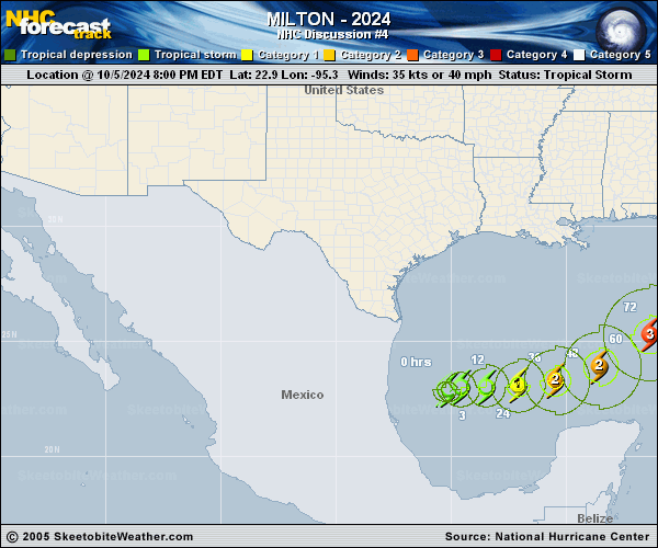
Copy of official data Tropical Storm Milton Discussion Number 4 NWS National Hurricane Center Miami FL AL142024 400 AM CDT Sun Oct 06 2024 Satellite imagery this morning suggests that Milton is getting better organized, with the central dense overcast getting larger and some outer banding forming in the western semicircle. Satellite intensity estimates currently range between 30-45 kt, and based on this and the increasing organization the initial intensity is set at 45 kt. A NOAA Hurricane Hunter aircraft is currently enroute to investigate Milton. Milton has turned eastward with the initial motion of 090/4 kt. Westerly flow on the south side of a shortwave trough over the northern Gulf of Mexico should steer the storm generally eastward during the next 36-48 h. After that, a second trough moving over the northwestern Gulf should cause the storm to turn northeastward toward the Florida Peninsula at a faster forward speed. While the track guidance is generally in good agreement on this scenario, there remains some spread in both the track and forward speed, so it is too early to specify which portions of the Florida Peninsula will get the worst impacts. After crossing Florida, Milton should turn eastward over the Atlantic in the mid-latitude westerly flow. The new forecast track is nudged a little south of the previous track and lies between the GFS and ECMWF models. It should be noted that the average NHC track error at day 4 is around 150 miles. Therefore, users are reminded to not focus on the exact track. The intensity forecast has a lot of complexities. First, Milton is a small cyclone, and such systems can both strengthen and weaken very rapidly. Second, while the cyclone is going to be in a favorable environment through about 60 h, it will encounter strong shear and dry air entrainment after that time. Third, the proximity of a frontal system over the northern Gulf of Mexico and Florida suggests the possibility that Milton will undergo extratropical transition at some point during the forecast period. The intensity guidance continues to show a significant spread in the forecast peak intensity in 60-72 h, with possibilities ranging from category 1 to category 5 strength. Also, some of the intensity guidance forecasts Milton to rapidly weaken over water after peak intensity, while other models suggest the storm will only weaken slightly. The new intensity forecast follows the trend of the guidance and shows Milton reaching a peak intensity of 105 kt at 72 h. However, this is below the intensity consensus, and it would not be surprising if the storm gets stronger. Milton is expected to weaken and start extratropical transition while over Florida, with the transition completed by 120 h. Regardless of the details, there is increasing confidence that a powerful hurricane with life-threatening hazards will be affecting portions of the Florida west coast around the middle of this week. Residents there should closely monitor this system and listen to local officials. Key Messages: 1. Milton is forecast to quickly intensify while it moves eastward to northeastward across the Gulf of Mexico and be at or near major hurricane strength when it reaches the west coast of the Florida Peninsula mid week. Hurricane Watches could be issued as early as late today for portions of Florida. 2. There is an increasing risk of life-threatening storm surge and wind impacts for portions of the west coast of the Florida Peninsula beginning late Tuesday or Wednesday. Residents in these areas should ensure they have their hurricane plan in place, follow any advice given by local officials, and check back for updates to the forecast. 3. Areas of heavy rainfall will impact portions of Florida Sunday and Monday well ahead of Milton, with heavy rainfall more directly related to the system expected later on Tuesday through Wednesday night. This rainfall brings the risk of flash, urban, and areal flooding, along with minor to moderate river flooding. FORECAST POSITIONS AND MAX WINDS INIT 06/0900Z 23.0N 94.9W 45 KT 50 MPH 12H 06/1800Z 23.0N 94.1W 55 KT 65 MPH 24H 07/0600Z 22.9N 92.9W 65 KT 75 MPH 36H 07/1800Z 22.9N 91.4W 80 KT 90 MPH 48H 08/0600Z 23.4N 89.6W 90 KT 105 MPH 60H 08/1800Z 24.5N 87.4W 100 KT 115 MPH 72H 09/0600Z 26.0N 85.3W 105 KT 120 MPH 96H 10/0600Z 29.0N 80.7W 80 KT 90 MPH 120H 11/0600Z 31.0N 74.5W 55 KT 65 MPH...POST-TROP/EXTRATROP $$ Forecaster Beven |