Official Discussion issued by the National Hurricane Center
Leslie (AL132024) DATA RELEASED: 10/3/2024 9:00:00 AM UTC
|
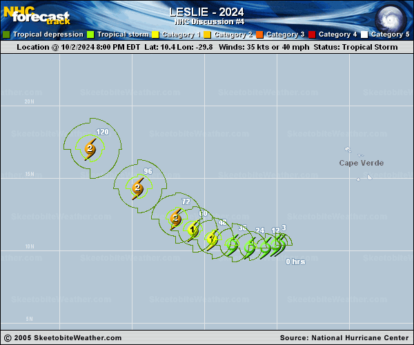
Copy of official data Tropical Storm Leslie Discussion Number 4 NWS National Hurricane Center Miami FL AL132024 500 AM AST Thu Oct 03 2024 The satellite structure of Leslie has changed little since the previous advisory, with small curved bands of convection primarily on the eastern side of the storm. Upper-level outflow from distant Hurricane Kirk continues to impinge on the western portion of the circulation. The initial intensity is held at 35 kt, in best agreement with a T2.5/35-kt TAFB subjective Dvorak classification. Leslie is moving slowly westward (265/5 kt) to the south of a subtropical ridge over the eastern Atlantic. A gradual turn to the west-northwest and northwest, along with a slight increase in forward speed, is forecast on Friday and over the weekend while the storm moves around the western extent of the ridge. The models are in reasonably good agreement on this scenario through the 5-day forecast period. The updated NHC prediction is virtually unchanged from the previous one, and lies near or in between the multi-model consensus aids HCCA and TVCA. As the distance between Kirk and slow-moving Leslie grows, the wind shear over Leslie should diminish. This will provide a more conducive environment for the storm to steadily strengthen within a moist environment over warm waters. There is some spread in the intensity guidance regarding how much strengthening will occur during the next 2-3 days, with the HAFS-A/B models much higher than the global models and statistical-dynamical aids. Given the storm's current structure and slow forward speed, the NHC forecast remains near the middle of the guidance envelope, closest to the IVCN simple consensus aid. This forecast brings Leslie to hurricane strength by early Saturday. As previously noted, the intensity of Leslie could plateau thereafter if it follows a similar track to Kirk and encounters the cool wake left behind by the hurricane. FORECAST POSITIONS AND MAX WINDS INIT 03/0900Z 10.3N 30.5W 35 KT 40 MPH 12H 03/1800Z 10.1N 31.2W 40 KT 45 MPH 24H 04/0600Z 10.2N 32.3W 50 KT 60 MPH 36H 04/1800Z 10.5N 33.6W 60 KT 70 MPH 48H 05/0600Z 11.1N 35.0W 70 KT 80 MPH 60H 05/1800Z 11.8N 36.4W 80 KT 90 MPH 72H 06/0600Z 12.7N 37.6W 85 KT 100 MPH 96H 07/0600Z 15.3N 40.4W 85 KT 100 MPH 120H 08/0600Z 18.0N 44.0W 90 KT 105 MPH $$ Forecaster Reinhart |