Official Discussion issued by the National Hurricane Center
Isaac (AL102024) DATA RELEASED: 9/26/2024 9:00:00 PM UTC
|
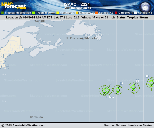
Copy of official data Tropical Storm Isaac Discussion Number 4 NWS National Hurricane Center Miami FL AL102024 500 PM AST Thu Sep 26 2024 Little change with the structure of Isaac has been noted this afternoon. Episodic bursts of deep convection have been observed over the western semi-circle throughout the day, but cloud tops have largely failed to break -60C. There remains a relative void of thunderstorms over the eastern half of Isaac's circulation as it traverses across 26C water. ASCAT passes, combined with a blend of subjective Dvorak estimates from TAFB and SAB, plus objective estimates from UW-CIMSS collectively support maintaining an initial intensity of 45 kt for this advisory. For the next couple of days, the track guidance is tightly clustered as Isaac continues on a general east to east-northeast heading, remaining embedded within a well established mid-latitude trough. Beyond Saturday, there has been a large change in the dynamic model suite. A vast majority of the the guidance, including the deterministic ECMWF and several of its ensemble members, have shown a rather dramatic poleward shift, similar to previous runs of the GFS. This is ultimately induced by a slight decrease in forward speed, which in turn allows Isaac to be steered by a strong closed mid-latitude trough digging out of eastern Canada into the north Atlantic. This would force Isaac to the northeast and eventually northward. Isaac's medium range track confidence is quite low, owing to lack of model consistency during the past several runs. To avoid making too large of a change, the forecast track after Day 3 has shifted to the left for this advisory. However, it falls well to the east of the guidance envelope and further large changes may be needed. Despite the longer range track uncertainty, Isaac appears to be in an environment that should be generally conducive for some strengthening, especially during the next day or two. After that, unusually cold upper-tropospheric temperatures should help sustain the tropical cyclone for a while, even as it moves over colder SSTs in the 24-25 deg C range. By the end of the forecast period, much colder SSTs and a dramatic increase in shear should cause Isaac to become post-tropical. This transition could occur more quickly than forecast if the system takes a more northerly turn early next week. No changes of note were made to the official intensity forecast, which still shows Isaac reaching hurricane strength during the next couple of days. FORECAST POSITIONS AND MAX WINDS INIT 26/2100Z 37.5N 50.6W 45 KT 50 MPH 12H 27/0600Z 37.6N 48.7W 50 KT 60 MPH 24H 27/1800Z 38.2N 45.5W 60 KT 70 MPH 36H 28/0600Z 39.2N 42.0W 65 KT 75 MPH 48H 28/1800Z 40.5N 38.7W 65 KT 75 MPH 60H 29/0600Z 41.9N 35.9W 60 KT 70 MPH 72H 29/1800Z 43.0N 33.8W 60 KT 70 MPH 96H 30/1800Z 44.2N 27.8W 50 KT 60 MPH...POST-TROP/EXTRATROP 120H 01/1800Z 45.5N 22.5W 40 KT 45 MPH...POST-TROP/EXTRATROP $$ Forecaster D. Zelinsky/Bookbinder |