Official Discussion issued by the National Hurricane Center
(AL092024) DATA RELEASED: 9/24/2024 9:00:00 AM UTC
|
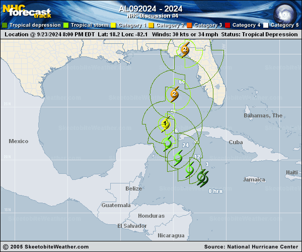
Copy of official data Potential Tropical Cyclone Nine Discussion Number 4 NWS National Hurricane Center Miami FL AL092024 500 AM EDT Tue Sep 24 2024 Satellite images indicate that the system remains poorly organized. A large area of deep convection is on the eastern side of the broad circulation with no defined central features, and dropsondes from the Air Force and NOAA aircraft indicate that low-level circulation remains poorly defined. The initial wind speed is kept at 30 kt, in agreement with many dropsondes around that value. The best estimate of initial motion is northwestward at about 7 kt. This general motion is expected today while the disturbance moves around a high-pressure area over the southeastern United States. The cyclone is expected to gradually turn northward on Wednesday as the high shifts eastward ahead of a mid-level trough dropping into the south-central United States. This evolution of the steering pattern should cause the system to accelerate northward to north-northeastward over the eastern Gulf of Mexico and toward the northeastern Gulf Coast through Thursday. The biggest change to the model guidance overnight is that the guidance mean is a bit slower, with the GFS model faster than most of the aids. However, this remains a very consistent set of models, and very little overall change was made to the official forecast. Hopefully an ongoing NOAA G-IV aircraft mission will help provide useful data for any future track refinements. Southwesterly shear continues over the disturbance, though the models are insistent that this shear will abate as an upper-level low over the northeastern Yucatan Peninsula weakens today and tomorrow. Otherwise, conditions look quite favorable for strengthening over the eastern Gulf of Mexico on Wednesday and Thursday, with the system likely moving over extremely deep and warm waters, along with a favorable trough interaction, and many of the forecast aids are showing rapid intensification over the eastern Gulf of Mexico. The intensity guidance is very close to the previous NHC intensity forecast and continues to indicate that this system will become quite large and powerful before landfall. Due to the forecast large size of this system, storm surge, wind, and rainfall impacts will extend well away from the center, particularly on the east side. In addition, the fast forward speed while it crosses the coast will likely result in farther inland penetration of strong winds over parts of the southeastern United States after landfall. Hurricane and Storm Surge Watches have been issued this morning, and further watches and warnings are likely later today. KEY MESSAGES: 1. The disturbance is forecast to intensify and be near hurricane strength when it reaches the far northwestern Caribbean Sea early Wednesday. Tropical storm conditions are expected over portions of western Cuba and the northeastern coast of the Yucatan Peninsula with hurricane conditions possible. 2. The system is expected to intensify into a major hurricane before it approaches the northeastern Gulf Coast on Thursday, and the potential for life-threatening storm surge and damaging hurricane-force winds along the coast of the Florida Panhandle and the Florida west gulf coast is increasing. Hurricane and Storm Surge Watches have been issued, and residents should ensure they have their hurricane plan in place, and also follow advice given by local officials. 3. Potential Tropical Cyclone Nine will bring heavy rain to portions of the western Caribbean, which will cause considerable flooding and mudslides across western Cuba. Heavy rainfall will likely result in locally considerable flash and urban flooding across portions of Florida, with isolated flash and urban flooding possible across the Southeast, Southern Appalachians, and the Tennessee Valley Wednesday through Friday. Minor to isolated moderate river flooding will be possible. FORECAST POSITIONS AND MAX WINDS INIT 24/0900Z 18.9N 83.0W 30 KT 35 MPH...POTENTIAL TROP CYCLONE 12H 24/1800Z 19.6N 84.2W 40 KT 45 MPH...TROPICAL CYCLONE 24H 25/0600Z 20.7N 85.7W 50 KT 60 MPH 36H 25/1800Z 22.0N 86.2W 65 KT 75 MPH 48H 26/0600Z 24.3N 85.6W 80 KT 90 MPH 60H 26/1800Z 27.8N 84.4W 100 KT 115 MPH 72H 27/0600Z 31.9N 83.5W 60 KT 70 MPH...INLAND 96H 28/0600Z 38.5N 85.5W 15 KT 15 MPH...POST-TROPICAL 120H 29/0600Z...DISSIPATED $$ Forecaster Blake |