Official Discussion issued by the National Hurricane Center
Seven (AL072024) DATA RELEASED: 9/12/2024 9:00:00 AM UTC
|
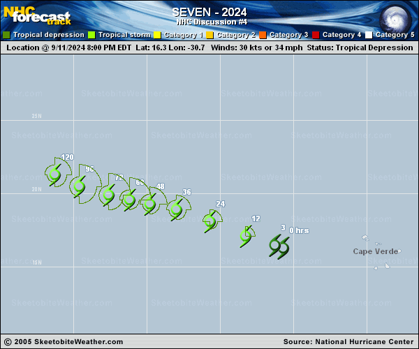
Copy of official data Tropical Depression Seven Discussion Number 4 NWS National Hurricane Center Miami FL AL072024 500 AM AST Thu Sep 12 2024 The system has changed little in organization overnight, with limited deep convection and slight banding features. An AMSR-2 microwave image suggested that the circulation was still somewhat broad since the cloud bands were not very tightly curved. Subjective Dvorak classifications from TAFB and SAB were T2.5/35 kt and T2.0/30 kt, respectively. The advisory intensity is held at 30 kt given the depression's lack of increased organization. This is also in agreement with a DMINT objective intensity estimate from UW-CIMSS based on the AMSR data. The cyclone continues on a west-northwestward heading with an estimated motion of 290/15 kt. A gradually weakening ridge over the eastern subtropical Atlantic should maintain this general motion with decreasing forward speed over the next 2-3 days. Later in the forecast period, an amplifying trough is expected to erode the ridge, which should cause the cyclone to turn at least a little to the right. The track guidance becomes somewhat divergent in the 4- to 5-day time frame, but is in overall agreement on a rather slow motion. The official track forecast is similar to the previous NHC prediction and close to the various dynamical model consensus solutions. Environmental conditions seem fairly conducive for at least gradual strengthening during the next few days, with low- to moderate-vertical wind shear and marginally warm SSTs. However, the models are not very bullish on strengthening until near the end of the forecast period. This may be due to a somewhat stable air mass over the eastern Atlantic. The official intensity forecast is similar to the Decay-SHIPS model guidance through 72 hours, but shows no change after that time given the uncertainties in intensity prediction. FORECAST POSITIONS AND MAX WINDS INIT 12/0900Z 17.3N 33.0W 30 KT 35 MPH 12H 12/1800Z 18.1N 34.9W 35 KT 40 MPH 24H 13/0600Z 18.9N 37.4W 35 KT 40 MPH 36H 13/1800Z 19.4N 39.3W 40 KT 45 MPH 48H 14/0600Z 19.7N 41.0W 45 KT 50 MPH 60H 14/1800Z 19.9N 42.3W 45 KT 50 MPH 72H 15/0600Z 20.0N 43.6W 45 KT 50 MPH 96H 16/0600Z 20.7N 45.6W 45 KT 50 MPH 120H 17/0600Z 21.2N 47.1W 45 KT 50 MPH $$ Forecaster Pasch |