Official Discussion issued by the National Hurricane Center
Beryl (AL022024) DATA RELEASED: 7/7/2024 4:00:00 PM UTC
|
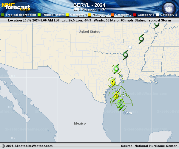
Copy of official data Tropical Storm Beryl Discussion Number 37 NWS National Hurricane Center Miami FL AL022024 400 PM CDT Sun Jul 07 2024 Satellite images indicate that Beryl continues to gradual organize with more banding features near the center, expanding outflow and strong bursts of convection rotating around the eyewall. However, dry air is still present within the inner core, keeping the intensification slow at this time, with only a broken banded eyewall structure. While the central pressure reported by an Air Force Reserve Hurricane Hunter aircraft has fallen to 988 mb, there hasn't been much change in the winds reported, so the intensity remains 55 kt. The intensity forecast is tricky because the environment is becoming quite favorable for significant intensification as Beryl should be moving over sea-surface temperatures near 87F tonight and light shear, plus even an enhancement of jet dynamics north of the storm. All of the model guidance respond to these conditions by showing a large increase in deep convection near the center and higher winds. However, some less predictable factors could prevent a big increase in winds, including dry air in the inner core, a somewhat large radius of maximum winds, and slightly faster landfall timing. Given that the regional hurricane models still show significant deepening, the official forecast continues to call for near rapid intensification through landfall. Beryl has turned north-northwest at about 10 kt. The storm should turn northward overnight before making landfall along the middle Texas coast early on Monday before dawn. The new forecast is very close to the previous one through landfall. After Beryl moves inland, the latest guidance turns the system northeastward late tomorrow and it becomes a post-tropical cyclone. The long-term track is a bit faster and east of the last one, consistent with a blend of the ECMWF and GFS models. Key Messages: 1. There is a danger of life-threatening storm surge inundation along the coast of Texas from the north entrance to the Padre Island National Seashore to Sabine Pass, including Matagorda Bay and Galveston Bay. Residents in those areas should follow any advice given by local officials and follow evacuation orders. 2. Beryl is forecast to bring damaging hurricane-force winds to portions of the Texas coast tonight and early Monday. A Hurricane Warning is in effect from Baffin Bay to San Luis Pass. 3. Considerable flash and urban flooding is expected tonight through Monday night across portions of the middle and upper Texas Gulf Coast and eastern Texas. Minor to isolated major river flooding is also expected. 4. Rip currents will cause life-threatening beach conditions through Monday across much of the Gulf Coast. Beachgoers should heed warning flags and the advice of lifeguards and local officials before venturing into the water. FORECAST POSITIONS AND MAX WINDS INIT 07/2100Z 26.8N 95.5W 55 KT 65 MPH 12H 08/0600Z 28.3N 95.9W 75 KT 85 MPH 24H 08/1800Z 30.4N 95.9W 50 KT 60 MPH...INLAND 36H 09/0600Z 32.6N 94.8W 30 KT 35 MPH...INLAND 48H 09/1800Z 34.9N 92.6W 25 KT 30 MPH...POST-TROP/INLAND 60H 10/0600Z 37.2N 89.7W 20 KT 25 MPH...POST-TROP/INLAND 72H 10/1800Z 39.7N 86.2W 20 KT 25 MPH...POST-TROP/INLAND 96H 11/1800Z 43.5N 80.0W 25 KT 30 MPH...POST-TROP/INLAND 120H 12/1800Z...DISSIPATED $$ Forecaster Blake |