Official Discussion issued by the National Hurricane Center
Beryl (AL022024) DATA RELEASED: 7/7/2024 4:00:00 AM UTC
|
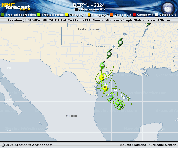
Copy of official data Tropical Storm Beryl Discussion Number 35 NWS National Hurricane Center Miami FL AL022024 400 AM CDT Sun Jul 07 2024 The convective structure of Beryl continues to wax and wane, with some deep convection now attempting to redevelop on the western and southern side of the circulation, as evident on both GOES-16 satellite and radar imagery out of Brownsville, TX. The Air Force Hurricane Hunter aircraft that departed the storm a few hours ago provided a last fix with 700-mb winds of 56 kt in the northeastern quadrant and a pressure of 995 mb. Since there has not been much meaningful change to the tropical storm's structure since that time, the initial intensity will remain 50 kt for this advisory. Beryl continues to move northwestward, though a little more poleward than before estimated at 320/10 kt. Over the next 24 hours, Beryl is expected to turn north-northwestward or even northward before the system makes landfall along the Texas coast in a little more than 24 hours. The track guidance this cycle has made a shift eastward and is a little faster, and the NHC track forecast has also shifted in that direction, in between the latest TCVN and HCCA consensus aids. It is worth noting that some guidance, such as the GFS and HAFS-A are even further east. After Beryl moves inland, the latest guidance shows the system accelerating farther northeastward, ultimately phasing with a mid-latitude trough over the Ohio Valley while it transitions into a post-tropical cyclone. Even though Beryl has not intensified over the past day, vertical wind shear is in the process of decreasing below 10 kt over the storm this morning, which should provide it with a 24-30 hour window to start intensifying as it mixes out the dry air that prevented persistent organized convection around the core. The fastest rate of intensification is likely to occur right before landfall, and the latest intensity forecast still shows Beryl becoming a hurricane again in 24 hours, with some additional intensification possible right up until landfall. This forecast is consistent with the hurricane-regional models that also show the most significant intensification right before Beryl makes landfall. There also remains some potential that Beryl could rapidly intensify before landfall, with the latest SHIPS-RII suggesting this possibility is 2-3 times above climatology. It is important to note that the average NHC track error at 24-36 hours is about 30-50 miles and the average intensity error is close to one category. Users are reminded to consider these uncertainties when using the forecast information. Based on changes to the forecast track this advisory, Hurricane Warnings have been extended northward up to San Luis Pass. Key Messages: 1. There is a danger of life-threatening storm surge inundation late tonight and Monday along the coast of Texas from the north entrance to the Padre Island National Seashore to High Island, including Corpus Christi Bay, Matagorda Bay, and Galveston Bay. Residents in those areas should follow any advice given by local officials and follow evacuation orders. 2. Beryl is forecast to bring damaging hurricane-force winds to portions of the Texas coast late tonight and Monday. A Hurricane Warning is now in effect from Baffin Bay to San Luis Pass. Preparations should be rushed to completion before tropical storm conditions begin late today. 3. Flash and urban flooding, some of which may be locally considerable, is expected across portions of the middle and upper Texas Gulf Coast and eastern Texas today through Monday night. River flooding is also expected. 4. Rip currents will cause life-threatening beach conditions through Monday across much of the Gulf Coast. Beachgoers should heed warning flags and the advice of lifeguards and local officials before venturing into the water. FORECAST POSITIONS AND MAX WINDS INIT 07/0900Z 25.3N 94.6W 50 KT 60 MPH 12H 07/1800Z 26.3N 95.4W 60 KT 70 MPH 24H 08/0600Z 28.1N 96.1W 75 KT 85 MPH 36H 08/1800Z 30.2N 96.1W 45 KT 50 MPH...INLAND 48H 09/0600Z 32.5N 95.1W 30 KT 35 MPH...INLAND 60H 09/1800Z 34.7N 93.3W 25 KT 30 MPH...POST-TROP/INLAND 72H 10/0600Z 36.7N 91.6W 20 KT 25 MPH...POST-TROP/INLAND 96H 11/0600Z 40.5N 87.0W 20 KT 25 MPH...POST-TROP/INLAND 120H 12/0600Z 43.5N 83.5W 20 KT 25 MPH...POST-TROP/INLAND $$ Forecaster Papin |