Official Discussion issued by the National Hurricane Center
Leslie (AL132024) DATA RELEASED: 10/10/2024 9:00:00 PM UTC
|
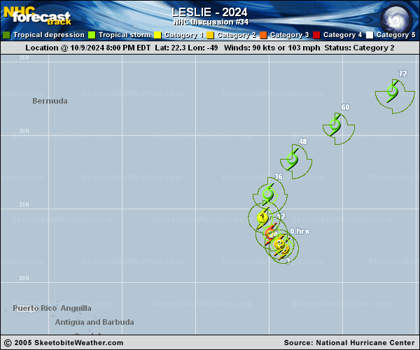
Copy of official data Tropical Storm Leslie Discussion Number 34 NWS National Hurricane Center Miami FL AL132024 500 PM AST Thu Oct 10 2024 The center of Leslie has been exposed for the past 6 h, thanks to strong northerly wind shear. The center has continued to move farther away from the convection as the afternoon has progressed. The initial intensity is brought down to 60 kt, which agrees with a blend of the various objective intensity estimates from UW-CIMSS. Leslie continues to plow through a zone of strong northerly shear, and the SHIPS guidance and model fields indicate Leslie will continue to experience 40 kt of northerly to northeasterly shear for another 12 to 24 h. In addition, Leslie is forecast to continue moving through a relatively dry environment. Rapid weakening is expected to continue over the next 12 to 24 h, and the latest NHC intensity forecast is lower than the previous one due to the weaker initial intensity. If Leslie survives as a tropical cyclone for another two days, which is not guaranteed, it will approach a frontal zone in 2 to 3 days and could take on some frontal characteristics. While all of the models show Leslie dissipating by 4 to 5 days, there is significant uncertainty on whether Leslie will become extratropical or just dissipate. Leslie is moving northwestward, or 315/7 kt. Model guidance is in good agreement that a northward turn will happen very soon as Leslie moves around the southwestern periphery of a subtropical ridge over the eastern Atlantic. On Friday and Friday night, the hurricane should speed up and turn to the northeast, followed by an east-northeastward turn as it accelerates further over the weekend. There is a bit of along-track spread in the guidance after 48 h, as some of the models show Leslie accelerating faster toward the east-northeast. Only minor changes are made to the previous NHC track to account for the models being slightly farther west during the first 36 h of the forecast. FORECAST POSITIONS AND MAX WINDS INIT 10/2100Z 23.9N 50.9W 60 KT 70 MPH 12H 11/0600Z 24.9N 51.1W 45 KT 50 MPH 24H 11/1800Z 27.0N 50.1W 40 KT 45 MPH 36H 12/0600Z 29.6N 47.6W 40 KT 45 MPH 48H 12/1800Z 32.5N 43.3W 40 KT 45 MPH 60H 13/0600Z 34.8N 38.2W 40 KT 45 MPH...POST-TROPICAL 72H 13/1800Z 36.1N 32.8W 40 KT 45 MPH...POST-TROPICAL 96H 14/1800Z 36.0N 23.5W 30 KT 35 MPH...POST-TROPICAL 120H 15/1800Z...DISSIPATED $$ Forecaster Hagen |