Official Discussion issued by the National Hurricane Center
(AL122024) DATA RELEASED: 10/7/2024 3:00:00 PM UTC
|
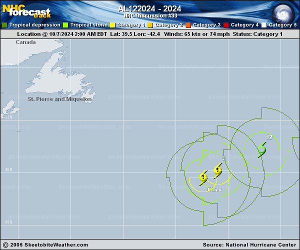
Copy of official data Post-Tropical Cyclone Kirk Discussion Number 33 NWS National Hurricane Center Miami FL AL122024 300 PM GMT Mon Oct 07 2024 Satellite imagery and model analyses indicate that Kirk has completed its transition to an extratropical cyclone. Therefore, this will be the final NHC advisory. Kirk is expected to remain a large and powerful extratropical cyclone over the next couple of days as it moves east-northeastward across the northeastern Atlantic Ocean toward western Europe. Gradual weakening is forecast, and the intensity forecast best matches the GFS and ECMWF global models. Very little change has been made to the previous NHC track forecast. The track forecast is near the consensus models. Kirk will be passing north of the Azores over the next 24 hours. Large breaking waves are likely along portions of the coasts of the Azores, along with gusty winds. Swells from Kirk may continue to induce a high rip current risk along portions of the U.S. East Coast for another day or so. These swells will affect Bermuda, Atlantic Canada and the Azores for a few more days. Kirk will move over western Europe by late Wednesday. Future information on this system can be found in High Seas Forecasts issued by the National Weather Service, under AWIPS header NFDHSFAT1, WMO header FZNT01 KWBC, and online at ocean.weather.gov/shtml/NFDHSFAT1.php FORECAST POSITIONS AND MAX WINDS INIT 07/1500Z 41.7N 38.4W 65 KT 75 MPH...POST-TROPICAL 12H 08/0000Z 43.1N 33.6W 60 KT 70 MPH...POST-TROP/EXTRATROP 24H 08/1200Z 43.5N 25.7W 55 KT 65 MPH...POST-TROP/EXTRATROP 36H 09/0000Z 43.7N 16.1W 50 KT 60 MPH...POST-TROP/EXTRATROP 48H 09/1200Z 45.4N 6.1W 45 KT 50 MPH...POST-TROP/EXTRATROP 60H 10/0000Z 48.5N 4.5E 35 KT 40 MPH...POST-TROP/EXTRATROP 72H 10/1200Z...DISSIPATED $$ Forecaster Hagen |