Official Discussion issued by the National Hurricane Center
Beryl (AL022024) DATA RELEASED: 7/6/2024 4:00:00 PM UTC
|
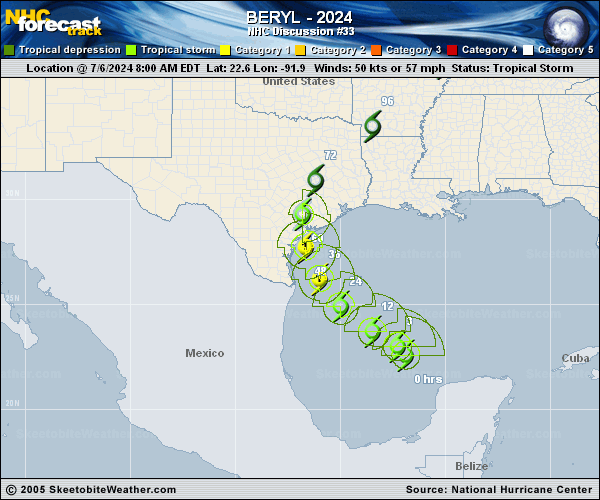
Copy of official data Tropical Storm Beryl Discussion Number 33 NWS National Hurricane Center Miami FL AL022024 400 PM CDT Sat Jul 06 2024 Beryl's convective organization has increased since the last advisory, with a ragged band forming in the western semicircle. However, this band is best organized around what appears to be a mid-level center to the north or northeast of the low-level center. Earlier aircraft data indicated that the maximum winds were near 50 kt and the central pressure was in the 997-999 mb range, and since that time various objective intensity estimates have shown little change. Thus, the initial intensity remains 50 kt. The next aircraft missions into the cyclone should arrive around 2300-0000Z. Beryl is still being affected by shear and dry air entrainment, which helped produce a large arc cloud that was visible for most of the day to the south and southwest of the convection. The initial motion is now 310/11 kt. Water vapor imagery continues to show a developing mid-latitude trough over the central United States that is opening a break in the subtropical ridge over Texas. Beryl should move northwestward for the next 24 h or so, then gradually turn north and move into the break. This motion should lead to the cyclone making landfall on the Texas coast between 36-48 h. Recurvature to the northeast is subsequently expected after 60-72 h. There has been a little bit of a northward shift in the guidance and track, due mainly to a more northward initial position. While this has produced only a small change in the forecast landfall location, the landfall time is now a few hours earlier than in the previous advisory. It should be noted that some erratic motion could occur tonight due to possible center reformations. While Beryl remains in an area of southerly vertical shear and mid- to upper-level dry air, the convection has been persistent during the past several hours. The shear is forecast to decrease by Sunday morning, which should allow Beryl to re-intensity as shown by all of the guidance. The intensity forecast calls for Beryl to regain hurricane status Sunday or Sunday night, and to reach an intensity of around 75-kt near the time of the Texas landfall. This intensity is based on the regional hurricane models, which have landfall intensities ranging from 65-85 kt. After landfall, Beryl is expected to weaken, with the system forecast to decay to a remnant low pressure area by 96 h. It is important to note that the average NHC track error at 36 hours is about 50-60 miles and the average intensity error is close to one category. Users are reminded to consider these uncertainties when using the forecast information. Key Messages: 1. There is a danger of life-threatening storm surge inundation late Sunday night and Monday along the coast of Texas from the north entrance to the Padre Island National Seashore to San Luis Pass. Residents in that area should follow any advice given by local officials and follow evacuation orders. 2. Beryl is forecast to bring damaging hurricane-force winds to portions of the lower and middle Texas coast late Sunday night and Monday. A Hurricane Warning is now in place from Baffin Bay to Sargent. Preparations should be rushed to completion before tropical storm conditions begin late Sunday. 3. Flash and urban flooding, some of which may be locally considerable, is likely across portions of the Texas Gulf Coast and eastern Texas beginning late Sunday through the middle of next week. River flooding is also possible. 4. Rip currents will cause life-threatening beach conditions through the weekend across much of the Gulf Coast. Beachgoers should heed warning flags and the advice of lifeguards and local officials before venturing into the water. FORECAST POSITIONS AND MAX WINDS INIT 06/2100Z 23.9N 93.0W 50 KT 60 MPH 12H 07/0600Z 24.8N 94.2W 55 KT 65 MPH 24H 07/1800Z 26.0N 95.5W 65 KT 75 MPH 36H 08/0600Z 27.5N 96.3W 75 KT 85 MPH 48H 08/1800Z 29.1N 96.7W 60 KT 70 MPH...INLAND 60H 09/0600Z 30.8N 96.4W 35 KT 40 MPH...INLAND 72H 09/1800Z 32.4N 95.2W 25 KT 30 MPH...INLAND 96H 10/1800Z 35.0N 91.5W 20 KT 25 MPH...POST-TROP/INLAND 120H 11/1800Z 38.0N 88.0W 20 KT 25 MPH...POST-TROP/INLAND $$ Forecaster Beven |