Official Discussion issued by the National Hurricane Center
Kirk (AL122024) DATA RELEASED: 10/7/2024 3:00:00 AM UTC
|
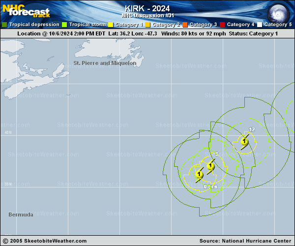
Copy of official data Hurricane Kirk Discussion Number 31 NWS National Hurricane Center Miami FL AL122024 300 AM GMT Mon Oct 07 2024 Kirk is in the process of transitioning into an extratropical cyclone. Satellite images show that the associated deep convection is now confined to the northern side of the circulation and that the inner core has been eroding. In addition, there appears to be some frontal features beginning to form. The initial intensity is lowered to 70 kt following a blend of the latest satellite intensity estimates. The 34-kt wind radii have been tweaked on the system's east side based on recent ASCAT data. Extratropical transition should be complete on Monday when the system moves over water temperatures in the low 20's C and into an environment of nearly 40 kt of vertical wind shear. These parameters will also cause steady weakening during the next few days, and dissipation seems likely by day 4. The models are in good agreement, and this forecast is closest to the latest GFS solution. Kirk is gradually turning to the right, and the latest initial motion is 045/22 kt. A turn to the east-northeast with a notable increase in forward speed is expected during the next few days as the system moves within the mid-latitude westerly flow. This should take the extratropical low to the north of the Azores on Tuesday and across western Europe on Wednesday. Although Kirk is over the open ocean, it is still producing large swells that could lead to life-threatening rip currents across portions of the Caribbean, Bermuda, the east coast of the U.S., and Atlantic Canada. FORECAST POSITIONS AND MAX WINDS INIT 07/0300Z 38.6N 43.6W 70 KT 80 MPH 12H 07/1200Z 41.0N 39.7W 65 KT 75 MPH...POST-TROP/EXTRATROP 24H 08/0000Z 42.9N 33.4W 60 KT 70 MPH...POST-TROP/EXTRATROP 36H 08/1200Z 43.5N 25.7W 55 KT 65 MPH...POST-TROP/EXTRATROP 48H 09/0000Z 43.8N 16.2W 50 KT 60 MPH...POST-TROP/EXTRATROP 60H 09/1200Z 45.6N 6.3W 45 KT 50 MPH...POST-TROP/EXTRATROP 72H 10/0000Z 48.1N 3.7E 40 KT 45 MPH...POST-TROP/EXTRATROP 96H 11/0000Z...DISSIPATED $$ Forecaster Cangialosi |