Official Discussion issued by the National Hurricane Center
Beryl (AL022024) DATA RELEASED: 7/6/2024 4:00:00 AM UTC
|
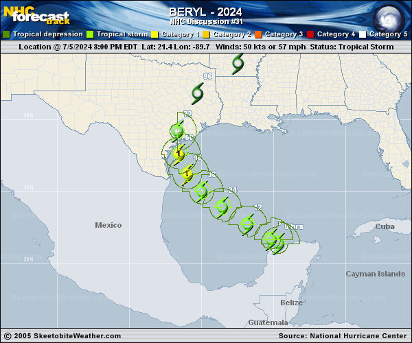
Copy of official data Tropical Storm Beryl Discussion Number 31 NWS National Hurricane Center Miami FL AL022024 400 AM CDT Sat Jul 06 2024 Beryl's structure this morning is a shadow of its former self in the Caribbean, with the low-level center partially exposed and displaced south of the best mid-level rotation and deep convection. The final couple of Air Force Hurricane Hunter fixes indicated the pressure was rising, though the aircraft did also observe 850-mb flight level winds of 65 kt, which still supports maintaining an initial intensity of 50 kt. This value is between the Dvorak intensity estimates provided by TAFB and SAB. Beryl's wind radii were adjusted some from to a combination of aircraft, scatterometer, and synthetic aperture radar wind data. Beryl is currently estimated to be moving west-northwest at 300/10-kt. Soon, the tropical storm is expected to turn more northwestward and gradually slow down as the steering currents evolve due to both a weakness developing in the subtropical ridge to the north, in addition to an upper-level low positioned west of Beryl also imparting more poleward steering. After the significant rightward shifts in the track guidance over the past day or so, the latest cycle has come into better agreement very near the previous NHC forecast track. In fact, the latest forecast track is very close to the prior forecast, roughly between the latest GFS and ECMWF forecasts. This track also splits the difference between the reliable TVCN and HCCA consensus aids. However, it should be noted that there still remains a fair amount of across-track spread in the latest ECMWF ensemble guidance at the time Beryl is forecast to make landfall in Texas on Monday. The poor structure of the tropical storm this morning does not favor much intensification in the short-term, and I suspect it will take another day or so for convection to reorganize around the inner core of Beryl. This process could also be slowed by a decent amount of dry air in the southern Gulf of Mexico being imported into Beryl's circulation by about 20 kt of southerly wind shear. However, this wind shear decreases to under 10 kt per SHIPS guidance after 24 hours as Beryl moves into very warm 29-30 C sea-surface temperatures. The upper-level low currently inducing the southerly shear will also become positioned farther southwest of Beryl, in a quadrant more favorable for TC intensification. Thus, strengthening is expected to begin on Sunday with the rate of intensification likely to increase in the final 24 hours before landfall, in agreement with the most favorable conditions being prescribed by the GFS and ECMWF models. The intensity forecast remains on the high side of the guidance envelope, but is also similar to the prior forecast and shows Beryl becoming a hurricane before reaching the Texas coast on Monday. It is important to note that the average NHC track error at 60 hours is about 80 miles and the average intensity error is close to one category. Users are reminded to consider these uncertainties when using the forecast information. Key Messages: 1. There is an increasing risk of damaging hurricane-force winds and life-threatening storm surge in portions of northeastern Mexico and the Texas Coast late Sunday into Monday, where Hurricane and Storm Surge Watches are in effect. Additional watches and warnings may be required later today. Interests in these areas should follow any advice given by local officials. 2. Flash and urban flooding, some of which may be locally considerable in nature, is likely across portions of the Texas Gulf Coast and eastern Texas beginning late Sunday through midweek. 3. Rip currents will cause life-threatening beach conditions through the weekend across much of the Gulf Coast. Beachgoers should heed warning flags and the advice of lifeguards and local officials before venturing into the water. FORECAST POSITIONS AND MAX WINDS INIT 06/0900Z 22.2N 91.3W 50 KT 60 MPH 12H 06/1800Z 23.3N 92.7W 50 KT 60 MPH 24H 07/0600Z 24.4N 94.3W 55 KT 65 MPH 36H 07/1800Z 25.6N 95.5W 60 KT 70 MPH 48H 08/0600Z 27.0N 96.4W 70 KT 80 MPH 60H 08/1800Z 28.5N 96.7W 80 KT 90 MPH...ON THE COAST 72H 09/0600Z 30.3N 96.5W 35 KT 40 MPH...INLAND 96H 10/0600Z 32.9N 94.0W 25 KT 30 MPH...POST-TROP/INLAND 120H 11/0600Z 35.5N 90.1W 20 KT 25 MPH...POST-TROP/INLAND $$ Forecaster Papin |