Official Discussion issued by the National Hurricane Center
Patty (AL172024) DATA RELEASED: 11/2/2024 9:00:00 PM UTC
|
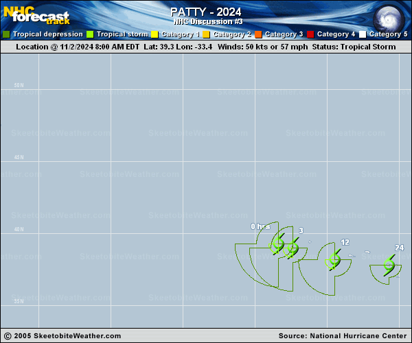
Copy of official data Subtropical Storm Patty Discussion Number 3 NWS National Hurricane Center Miami FL AL172024 900 PM GMT Sat Nov 02 2024 Patty has not changed much during the past several hours. The storm has been maintaining a small core, though the cloud tops are not as cold as they were earlier today. The system is still co-located with an upper-level low and dry and stable air continues to wrap around the core region. These mixed tropical and extratropical characteristics continue to support Patty's subtropical designation. The initial intensity is held at 55 kt based on the earlier ASCAT data, but this is above the latest satellite estimates. Patty is located about 60 n mi south of the westernmost Azores, and it will be passing near the central and eastern Azores later tonight and Sunday. Weakening should begin soon as the parent upper-level low weakens, leaving the storm in more stable conditions and stronger vertical wind shear. The models suggest that the low could lose its core and deep convection by late Sunday, which should cause it to become a post-tropical cyclone in 24 to 36 hours. Additional weakening is expected after that, and the storm will likely dissipate in 3 to 4 days. The subtropical storm is accelerating southeastward, and the latest initial motion estimate is 125/16 kt. An eastward motion is expected to begin overnight, taking Patty near or just south of the Azores through Sunday. An east-northeastward motion is expected after that toward western Europe. The models are in fairly good agreement, and this forecast remains near the middle of the guidance envelope. Key Messages: 1. Tropical storm conditions are expected in the Azores through Sunday, where Tropical Storm Warnings are in effect. 2. Locally heavy rains are possible across the Azores through Sunday. FORECAST POSITIONS AND MAX WINDS INIT 02/2100Z 38.0N 30.1W 55 KT 65 MPH 12H 03/0600Z 37.5N 27.0W 50 KT 60 MPH 24H 03/1800Z 37.3N 23.1W 45 KT 50 MPH 36H 04/0600Z 37.8N 19.0W 40 KT 45 MPH...POST-TROPICAL 48H 04/1800Z 39.0N 14.8W 35 KT 40 MPH...POST-TROPICAL 60H 05/0600Z 40.5N 11.4W 30 KT 35 MPH...POST-TROP/REMNT LOW 72H 05/1800Z 41.7N 9.8W 25 KT 30 MPH...POST-TROP/REMNT LOW 96H 06/1800Z...DISSIPATED $$ Forecaster Cangialosi |