Official Discussion issued by the National Hurricane Center
Twelve (AL122024) DATA RELEASED: 9/30/2024 9:00:00 AM UTC
|
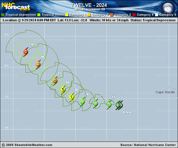
Copy of official data Tropical Depression Twelve Discussion Number 3 NWS National Hurricane Center Miami FL AL122024 500 AM AST Mon Sep 30 2024 Tropical Depression Twelve has become better organized overnight. A 29/2338 UTC ASCAT-B overpass showed a large area of 25 to 30 kt winds, and that the center was located near the northern edge of the large convective mass. Although a 30/0334 UTC AMSR2 microwave image showed that the center was still located near the northern edge of the central convective area, curved banding has been increasing during the night, with a large area of cold cloud tops persisting. Subjective Dvorak intensity estimates are a consensus T-2.0/30 kt from both TAFB and SAB. Objective intensity estimates from UW-CIMSS are rising and now range from 36 to 41 kt. Based on the subjective Dvorak estimates, a 30 kt initial intensity is held for this advisory, but the depression is likely very near tropical storm strength. The estimated initial motion of the depression is westward, or 275/7 kt. The cyclone will continue moving westward to west-northwestward for another couple days while a well-established subtropical ridge remains in place to the north of the system. A gradual turn to the northwest is expected around mid-week as a deep-layer trough over the north-central Atlantic weakens the ridge. At the end of the forecast period, an approaching upper-level trough near Bermuda will induce the cyclone to turn northward over the open waters of the central Atlantic Ocean. Some along-track spread is noted in the various track model solutions, but the models are in good agreement on the northward turn, with little cross-track spread. The latest NHC track forecast is nearly identical to the previous one, and is about halfway between the slower GFS solution and the faster ECMWF model. Conditions are quite favorable along the path of the depression with 29 degree C sea-surface temperatures, a moist environment, and weak vertical wind shear. Given the weak shear and the gradually improving structure, the cyclone should begin to steadily intensify soon. The depression is forecast to become a hurricane in 36 to 48 hours and a major hurricane in about 4 days. The NHC intensity forecast is similar to the previous one, and lies between the middle and upper end of the intensity guidance suite, near the HCCA and IVCN multi-model consensus aids. It should be noted that most of the models indicate that the cyclone's wind and wave field will expand significantly over the next several days, and the system is forecast to become a large and powerful hurricane as it gains latitude later this week. FORECAST POSITIONS AND MAX WINDS INIT 30/0900Z 14.0N 34.1W 30 KT 35 MPH 12H 30/1800Z 14.1N 35.7W 40 KT 45 MPH 24H 01/0600Z 14.3N 37.9W 50 KT 60 MPH 36H 01/1800Z 14.9N 39.8W 60 KT 70 MPH 48H 02/0600Z 15.8N 41.4W 70 KT 80 MPH 60H 02/1800Z 17.1N 42.7W 80 KT 90 MPH 72H 03/0600Z 18.4N 44.1W 90 KT 105 MPH 96H 04/0600Z 20.7N 46.5W 105 KT 120 MPH 120H 05/0600Z 23.4N 48.5W 105 KT 120 MPH $$ Forecaster Hagen |