Official Discussion issued by the National Hurricane Center
Joyce (AL112024) DATA RELEASED: 9/28/2024 3:00:00 AM UTC
|
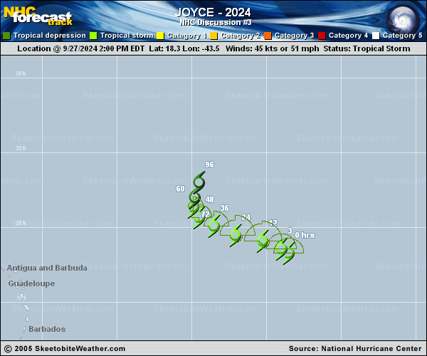
Copy of official data Tropical Storm Joyce Discussion Number 3 NWS National Hurricane Center Miami FL AL112024 1100 PM AST Fri Sep 27 2024 Recent microwave imagery, including an 0022 UTC ASCAT-B pass, indicates that Joyce's circulation is tilted with height, with a mid-level center feature displaced about 40 nm north of the low-level center. The scatterometer data also indicated that Joyce still has maximum winds of 45 kt, which is also supported by the latest TAFB and SAB Dvorak fixes. Joyce is moving toward the west-northwest (300/10 kt) to the south of a narrow subtropical ridge. Deep-layer troughing is forecast to amplify over the central Atlantic during the next few days, eroding the ridge and causing Joyce to gradually turn toward the northwest and north and slow down to a crawl by this time on Monday. Because several of the regional hurricane models appear to keep Joyce too strong in the coming days (more on that below) and show recurvature with acceleration, the NHC track forecast more closely follows the global models and is a blend of the previous forecast with the GFEX consensus. UW-CIMSS analyses and SHIPS diagnostics indicate that Joyce is being affected by moderate-to-strong southerly shear, which is reflected by the satellite presentation. This shear is not expected to abate during the next few days, and the storm will also be moving into a gradually drier and subsident environment. Therefore, the NHC intensity forecast calls for little change in strength during the next 24 hours, followed by gradual weakening thereafter. Joyce is likely to lose its organized convection and become a remnant low by day 3, if not sooner. The remnant low should degenerate into a trough by day 4 or 5 and will likely be absorbed by a larger weather system moving across the eastern Atlantic. FORECAST POSITIONS AND MAX WINDS INIT 28/0300Z 18.9N 44.7W 45 KT 50 MPH 12H 28/1200Z 19.3N 46.0W 45 KT 50 MPH 24H 29/0000Z 19.7N 47.7W 45 KT 50 MPH 36H 29/1200Z 20.3N 48.8W 40 KT 45 MPH 48H 30/0000Z 21.0N 49.5W 35 KT 40 MPH 60H 30/1200Z 21.6N 49.7W 30 KT 35 MPH 72H 01/0000Z 22.0N 49.7W 25 KT 30 MPH...POST-TROP/REMNT LOW 96H 02/0000Z 22.4N 49.7W 25 KT 30 MPH...POST-TROP/REMNT LOW 120H 03/0000Z...DISSIPATED $$ Forecaster Berg |