Official Discussion issued by the National Hurricane Center
Isaac (AL102024) DATA RELEASED: 9/26/2024 3:00:00 PM UTC
|
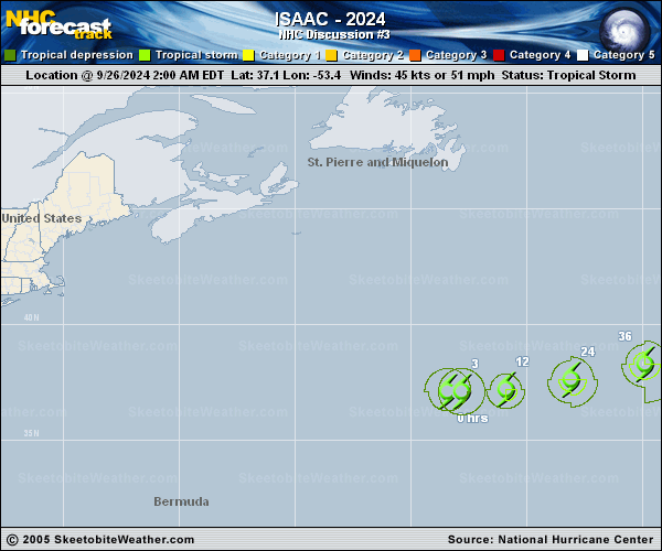
Copy of official data Tropical Storm Isaac Discussion Number 3 NWS National Hurricane Center Miami FL AL102024 1100 AM AST Thu Sep 26 2024 Isaac's structure has remained mostly steady state during the past 6 hours. Cloud tops associated with the tropical storm are still not particularly cold, but as noted in previous discussions, this is not unexpected for its synoptic environment. A blend of subjective Dvorak estimates from TAFB and SAB plus objective estimates from UW-CIMSS still supports an intensity of 45 kt for this advisory. For the next 48-60 h, the track forecast appears to be mostly straightforward. All reliable guidance indicates that Isaac will continue moving eastward to east-northeastward with a mid-latitude trough during that period. However, there is a significant bifurcation in the dynamical models after that. A majority of the guidance, including most of the ECMWF ensemble, indicate that Isaac will turn back eastward, continuing with the mid-latitude flow associated with another deep-layer trough. However, a few members of the global ensembles, plus the deterministic GFS, indicate Isaac could move slightly slower, which could cause the tropical storm to interact with a different trough, currently located over eastern Canada. This may cause the tropical cyclone to move northward after 60 h, on a very different track. The NHC forecast treats the GFS as an outlier, and is instead near the consensus of the remaining guidance. It is therefore very similar to the previous forecast. However, confidence in this forecast is particularly low, and we can't rule out needing to make an unusually large change to later forecasts. Isaac appears to be in an environment that should be generally conducive for some strengthening, especially during the next day or two. After that, unusually cold upper-tropospheric temperatures could help sustain the tropical cyclone for a while, even as it moves over colder SSTs in the 24-25 deg C. By the end of the forecast period, much colder SSTs and a dramatic increase in shear should cause Isaac to become post-tropical. No changes of note were made to the NHC forecast, which still shows Isaac reaching hurricane strength during the next couple of days. FORECAST POSITIONS AND MAX WINDS INIT 26/1500Z 37.3N 51.7W 45 KT 50 MPH 12H 27/0000Z 37.4N 49.8W 50 KT 60 MPH 24H 27/1200Z 37.9N 46.9W 55 KT 65 MPH 36H 28/0000Z 38.7N 43.5W 60 KT 70 MPH 48H 28/1200Z 39.9N 39.9W 65 KT 75 MPH 60H 29/0000Z 41.2N 36.7W 65 KT 75 MPH 72H 29/1200Z 42.3N 33.3W 60 KT 70 MPH 96H 30/1200Z 43.5N 25.5W 55 KT 65 MPH 120H 01/1200Z 43.5N 18.0W 45 KT 50 MPH...POST-TROP/EXTRATROP $$ Forecaster D. Zelinsky |