
Official Discussion issued by the National Hurricane Center
Isaias (AL092026) DATA RELEASED: 10/7/2026 4:00:00 AM UTC
|
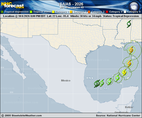
Copy of official data Tropical Storm Isaias Discussion Number 3 NWS National Hurricane Center Miami FL AL092026 400 AM CDT Wed Oct 07 2026 Satellite imagery depicts a bursting pattern with the tropical cyclone this morning, with cloud top temperatures below -85 C in the deep convection close to the estimated center. Earlier, an 0307 UTC ASCAT-C pass suggested the low-level circulation was still rather broad, with a peak wind retrieval of only 31 kt. However, the bursting convection already appears to be tightening up the circulation somewhat, with a nearby surface observation from a buoy north of the center recently reporting a sustained 10 m adjusted wind of 35 kt. This information is enough to upgrade the depression to Tropical Storm Isaias for this advisory. This initial intensity will be 35 kt, which also agrees with the 06 UTC Dvorak fix of T2.5/35 kt. Both Air Force Reserve and NOAA Hurricane Hunter reconnaissance missions are scheduled to sample the tropical storm later today. Isaias is estimated to be moving east-northeastward this morning at 075/7 kt. This general motion should continue today as the storm's steering is influenced by a zonally oriented mid-level trough currently draped along the northern Gulf coast. Over time, this trough is expected to be reinforced by another short-wave that is moving across the Rocky Mountains, with the trough ultimately sharpening up northwest of Isaias over Texas. At the same time, a subtropical ridge centered south of Bermuda is expected to shift westward, helping to enhance the deep-layer southerly flow over the eastern Gulf. Thus, Isaias is expected to turn northeastward and then northward on Thursday and Friday, making its approach to the northern Gulf coast in 60-72 h. As mentioned in the previous discussion, there remains quite a bit of along and across-track spread in the track guidance, with the AI-model guidance remaining on the east side, and physics-based models on the west side of the guidance envelope. The NHC track forecast continues to favor more of the eastward solutions, but not quite as far east as the latest HFIP Corrected Consensus Approach (HCCA) or Google DeepMind ensemble mean (GDMI). This latest track is a eastward shift compared to the previous forecast, but given large amount of across- and along-track spread users should continue to monitor forecast updates given the below-average track confidence. The short-term environment near Isaias is rather favorable, with very warm 30-31 C sea-surface temperatures, plenty of deep-layer moisture, with light to moderate shear diagnosed between 10-15 kt by SHIPS guidance. While it is difficult to get an exact gauge on the tropical storm's core structure since there have not been any recent microwave images, it is worth noting both the 00 UTC HAFS-A/B runs appeared to initialize with a broad structure similar to what was noted in the earlier ASCAT pass. Despite their initial broad structure, these hurricane-regional models show Isaias developing an inner-core rather quickly later today. There was a notable increase in the intensity aid guidance this forecast cycle, and the NHC intensity forecast is being raised accordingly, now showing Isaias reaching a peak intensity of 95 kt in 48 h while it is over the central Gulf. Vertical wind shear then increases quite dramatically in the final 24 hours before the cyclone reaches the northern Gulf coast, though it is looking more likely that Isaias will be a significant hurricane when it reaches the coast. Near landfall, Isaias will also be interacting with the short-wave trough, likely leading to an expanding wind field. Additional convective and motion asymmetries will likely cause rain and wind impacts to extend far from the center on the eastern side of the storm. Key Messages: 1. There is an increasing risk of dangerous wind and storm surge impacts along portions of the northern Gulf Coast. Residents from Louisiana to the Florida Panhandle should closely monitor the latest forecast updates and ensure they have their hurricane plan in place. Hurricane and Storm Surge Watches will likely be required for a portion of the northern Gulf coast later today. 2. Tropical Storm Isaias will bring areas of heavy rainfall to the central U.S. Gulf coast and much of the Southeast Friday into the weekend. Flash and urban flooding, along with isolated river flooding, will be possible. 3. Yucatan Peninsula of Mexico: Tropical Storm Isaias is expected to strengthen and could bring gusty winds and areas of heavy rain to the western portion of the Yucatan Peninsula over the next day or two. FORECAST POSITIONS AND MAX WINDS INIT 07/0900Z 22.0N 94.1W 35 KT 40 MPH 12H 07/1800Z 22.2N 92.9W 50 KT 60 MPH 24H 08/0600Z 22.7N 91.4W 65 KT 75 MPH 36H 08/1800Z 23.9N 89.7W 80 KT 90 MPH 48H 09/0600Z 25.5N 88.5W 95 KT 110 MPH 60H 09/1800Z 27.7N 87.7W 90 KT 105 MPH 72H 10/0600Z 30.8N 87.7W 75 KT 85 MPH...INLAND 96H 11/0600Z 38.2N 87.5W 25 KT 30 MPH...POST-TROP/INLAND 120H 12/0600Z...DISSIPATED $$ Forecaster Papin |