Official Discussion issued by the National Hurricane Center
Seven (AL072024) DATA RELEASED: 9/12/2024 3:00:00 AM UTC
|
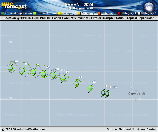
Copy of official data Tropical Depression Seven Discussion Number 3 NWS National Hurricane Center Miami FL AL072024 1100 PM AST Wed Sep 11 2024 Periodic bursts of convection have been growing and fading in the tropical depression this evening. Earlier microwave imagery from SSMIS showed a fragmented curved band wrapping around the northern and western portion of the circulation. Subjective estimates from TAFB and SAB were T-2.5/35 kt and T-1.5/25 kt respectively and based on a blend of these, the initial intensity is held at 30 kt. The depression is moving west-northwestward at 285/15 kt along the southern side of a mid-level ridge centered over the northeastern Atlantic. This motion should continue for the next day or so until the forward speed decreases when the ridge is eroded by an amplifying mid-level trough. By the end of the forecast period, the system should begin to turn northward toward a break in the ridge. Beyond 72 h, there is quite a bit of spread in the track guidance due to the models varying the timing of the turn to the north. The latest track forecast is similar to the previous prediction, and lies near the various consensus aids. Environmental conditions appear generally conducive for gradual strengthening for the next couple of days. Afterwards The depression is forecast to move into a drier air mass and it could experience moderate wind shear and possible dry air intrusions. The long range intensity forecast is also rather uncertain and few changes have been made to the new NHC intensity forecast, which lies near HCCA. FORECAST POSITIONS AND MAX WINDS INIT 12/0300Z 16.5N 31.3W 30 KT 35 MPH 12H 12/1200Z 17.1N 33.3W 35 KT 40 MPH 24H 13/0000Z 18.1N 35.7W 40 KT 45 MPH 36H 13/1200Z 18.9N 38.0W 45 KT 50 MPH 48H 14/0000Z 19.3N 39.8W 45 KT 50 MPH 60H 14/1200Z 19.6N 41.2W 40 KT 45 MPH 72H 15/0000Z 19.9N 42.6W 40 KT 45 MPH 96H 16/0000Z 20.5N 44.6W 40 KT 45 MPH 120H 17/0000Z 21.3N 46.3W 45 KT 50 MPH $$ Forecaster Bucci |