Official Discussion issued by the National Hurricane Center
Beryl (AL022024) DATA RELEASED: 6/29/2024 9:00:00 AM UTC
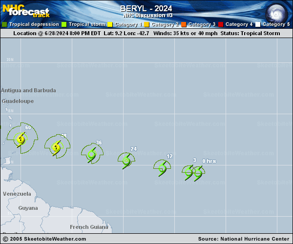
|
Copy of official data Tropical Storm Beryl Discussion Number 3 NWS National Hurricane Center Miami FL AL022024 500 AM AST Sat Jun 29 2024 Satellite imagery this morning shows that Beryl has become better organized, with the formation of a cold curved convective band near the center and over the western semicircle. However, AMSR-2 microwave data near 04Z suggested that the center of this convective curvature may have been displaced a little west of the low-level center. Based on the various subjective and objective satellite intensity estimates, the initial intensity is increased to a possibly conservative 45 kt. The cyclone currently has good anticyclonic outflow, especially in the western semicircle. The initial motion is 280/18 kt. Beryl is on the south side of a strong subtropical ridge, and this feature should steer the cyclone quickly westward or west-northwestward toward and through the Windward Islands during the next 2-3 days. After that time, there is some divergence in the track guidance as Beryl approaches a weakness in the subtropical ridge near and east of Florida. The GFS-based guidance calls for the storm to continue west- northwestward, while the ECMWF and UKMET models show a more westward motion. The consensus models lean more toward a west-northwestward motion, and the official forecast follows this guidance. The new forecast track has only minor changes from the previous track. Atmospheric and oceanic conditions over the western tropical Atlantic and the eastern Caribbean Sea are abnormally favorable for strengthening, and the rapid intensification indices in the SHIPS model are showing a significant chance of rapid intensification. The new intensity forecast continues to call for Beryl to become a hurricane before reaching the Windward Islands, and it now calls for a peak intensity of 95 kt in 60-72 h. This peak could be conservative, as several of the intensity guidance models forecast Beryl to become a major hurricane. After 72 h, the storm is expected to encounter increasing westerly shear, which should cause some weakening. Key Messages: 1. Tropical Storm Beryl is expected to strengthen and be a hurricane when it reaches the Windward Islands late Sunday night or Monday, bringing a risk of heavy rainfall, hurricane-force winds, and dangerous storm surge and waves. 2. A Hurricane Watch is now in effect for Barbados. Additional Hurricane and Tropical Storm Watches, and possibly Warnings, will likely be required for portions of the Windward and southern Leeward Islands later today. 3. Interests in the central and western Caribbean should monitor the progress of this system. Users are reminded that there is large uncertainty at days 4 and 5 and to not focus on the specific details of the track or intensity forecast. FORECAST POSITIONS AND MAX WINDS INIT 29/0900Z 9.8N 45.5W 45 KT 50 MPH 12H 29/1800Z 10.3N 48.1W 55 KT 65 MPH 24H 30/0600Z 11.0N 51.6W 65 KT 75 MPH 36H 30/1800Z 11.6N 55.0W 75 KT 85 MPH 48H 01/0600Z 12.4N 58.4W 85 KT 100 MPH 60H 01/1800Z 13.3N 62.0W 95 KT 110 MPH 72H 02/0600Z 14.4N 65.7W 95 KT 110 MPH 96H 03/0600Z 16.8N 73.0W 90 KT 105 MPH 120H 04/0600Z 19.0N 79.0W 75 KT 85 MPH $$ Forecaster Beven |