Official Discussion issued by the National Hurricane Center
Kirk (AL122024) DATA RELEASED: 10/6/2024 9:00:00 AM UTC
|
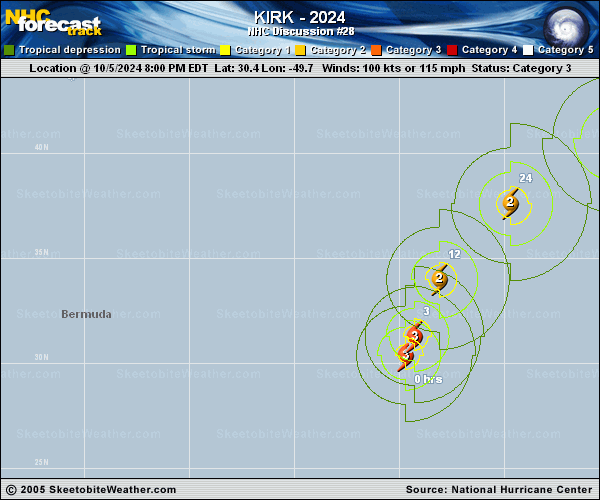
Copy of official data Hurricane Kirk Discussion Number 28 NWS National Hurricane Center Miami FL AL122024 500 AM AST Sun Oct 06 2024 Kirk continues to show the ill effects of increasing southwesterly shear. Earlier scatterometer data and recent satellite images suggest the hurricane is vertically tilted, with the low-level center displaced to the southwest of the mid-level circulation. The eye feature that was evident earlier today has filled, and satellite intensity estimates are decreasing. Kirk's initial intensity is estimated to be 90 kt, in best agreement with a T5.0 Dvorak Current Intensity estimate from TAFB and recent UW-CIMSS D-MINT and D-PRINT estimates. The wind radii of Kirk were made slightly larger based on partial data from a 0014 UTC ASCAT-C overpass. Kirk is expected to continue weakening during the next several days due to the negative influences of increasing vertical wind shear, decreasing SSTs, and a progressively drier mid-level environment. However, the expansive wind field of Kirk should remain large while the cyclone acquires frontal characteristics and transitions to an extratropical cyclone by 48 h. It is possible that the hostile conditions could cause Kirk to lose organized convection and become post-tropical even sooner than forecast. The updated NHC intensity forecast was adjusted downward to follow the latest HCCA and IVCN consensus trends. The hurricane is moving north-northeastward (015/20 kt) within the flow between an eastern Atlantic subtropical ridge and a deep-layer trough to the west of Kirk. The various track models agree that Kirk will continue accelerating deeper into the mid-latitudes while turning northeastward and east-northwestward over the next few days. The NHC forecast is very similar to the previous prediction, showing the center of Kirk passing north of the Azores Monday night into Tuesday as an extratropical cyclone and moving over western Europe during the middle of the week. Large swells from Kirk are propagating far away from the hurricane and bringing an increased risk of dangerous surf and rip currents to portions of the Leeward Islands, the Greater Antilles, the Bahamas, Bermuda, the U.S. East Coast, and Atlantic Canada. These swells are expected to spread toward the Azores on Monday. For more information on this hazard, see products issued by your local weather office. FORECAST POSITIONS AND MAX WINDS INIT 06/0900Z 33.5N 49.0W 90 KT 105 MPH 12H 06/1800Z 36.2N 47.0W 80 KT 90 MPH 24H 07/0600Z 39.6N 42.6W 70 KT 80 MPH 36H 07/1800Z 42.2N 36.7W 65 KT 75 MPH 48H 08/0600Z 43.4N 29.4W 55 KT 65 MPH...POST-TROP/EXTRATROP 60H 08/1800Z 43.9N 20.3W 50 KT 60 MPH...POST-TROP/EXTRATROP 72H 09/0600Z 45.5N 10.0W 45 KT 50 MPH...POST-TROP/EXTRATROP 96H 10/0600Z 51.5N 7.5E 30 KT 35 MPH...POST-TROP/EXTRATROP 120H 11/0600Z...DISSIPATED $$ Forecaster Reinhart |