Official Discussion issued by the National Hurricane Center
Beryl (AL022024) DATA RELEASED: 7/5/2024 10:00:00 AM UTC
|
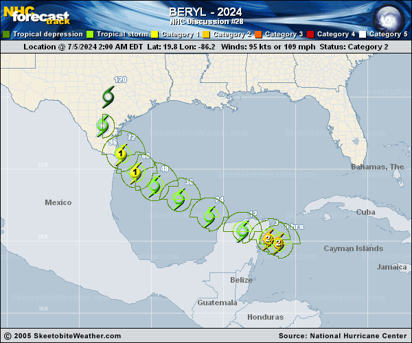
Copy of official data Hurricane Beryl Discussion Number 28 NWS National Hurricane Center Miami FL AL022024 1000 AM CDT Fri Jul 05 2024 The center of Beryl made landfall on the Yucatan Peninsula of Mexico just northeast of Tulum at about 11Z. The landfall intensity is somewhat uncertain, but surface observations suggest the central pressure rose into the 977-980 mb range before landfall. The cyclone is now weakening as it moves farther inland, and the initial intensity is reduced to 75 kt. The initial motion is now 290/14 kt. For the next 24 h or so, Beryl should be steered generally west-northwestward by the western portion of the subtropical ridge over the southeastern United States. After that, a turn toward the northwest is likely as the storm moves towards a break in the ridge caused by a combination of a trough in the mid-latitude westerlies over the central United States and an upper-level trough moving westward over the southwestern Gulf of Mexico. This motion should bring the center near the western Gulf coast in about 72 h. Subsequently, a northward motion through the break appears likely. While the track guidance has come into better agreement, there is still uncertainty based on the possible strength and vertical depth of Beryl. A stronger and vertically deeper cyclone would feel more steering from upper-level southwesterly flow caused by the Gulf trough, and thus would have a more northward motion, while a weaker system would probably continue more northwestward. Overall the guidance favors the more northward motion and has shifted a little to the right, and the new official forecast also is nudged a little to the right of the previous forecast. Additional adjustments of the forecast track could be necessary later today. Beryl should continue to weaken while over land, and it is expected to emerge over the Gulf of Mexico as a tropical storm. After that, it could take 12-24 h for the cyclone's structure to recover over the Gulf of Mexico before re-intensification can begin in earnest. Based on this and the overall trends of the intensity guidance, the new forecast calls for gradual strengthening to start after 24 h and continue until landfall. One important note is that the GFS and ECMWF suggest that ongoing westerly shear could decrease after 48-60 h, accompanied by an increase in upper-level divergence. Should this occur, Beryl could strengthen more than currently forecast, especially if the center stays over water longer than forecast. Users are reminded that the average NHC track error at day 3 is around 100 miles, and it remains too soon to pinpoint where the greatest impacts will be. However, watches for portions of northeastern Mexico and South Texas will likely be required later today. Key Messages: 1. Dangerous winds, storm surge, and heavy rainfall will continue over portions of the Yucatan Peninsula within the warning areas today. Residents there should shelter in place until these life-threatening conditions subside. 2. There is an increasing risk of hurricane-force winds, life-threatening storm surge, and flooding from heavy rainfall in portions of northeastern Mexico and the lower and middle Texas coast late Sunday and Monday. Interests in these areas should closely monitor updates to the forecast. Storm Surge, Hurricane and Tropical Storm Watches will likely be issued later today. 3. Rip currents will cause life-threatening beach conditions beginning late today and continuing through the weekend across much of the Gulf coast. Beachgoers should heed warning flags and the advice of lifeguards and local officials before venturing into the water. FORECAST POSITIONS AND MAX WINDS INIT 05/1500Z 20.7N 88.3W 75 KT 85 MPH...INLAND 12H 06/0000Z 21.4N 90.1W 55 KT 65 MPH...OVER WATER 24H 06/1200Z 22.5N 92.2W 55 KT 65 MPH 36H 07/0000Z 23.6N 94.1W 60 KT 70 MPH 48H 07/1200Z 24.6N 95.6W 65 KT 75 MPH 60H 08/0000Z 25.6N 96.6W 70 KT 80 MPH 72H 08/1200Z 26.8N 97.5W 75 KT 85 MPH...NEAR COAST 96H 09/1200Z 29.0N 98.0W 35 KT 40 MPH...INLAND 120H 10/1200Z 31.0N 97.0W 25 KT 30 MPH...INLAND $$ Forecaster Beven |