Official Discussion issued by the National Hurricane Center
Leslie (AL132024) DATA RELEASED: 10/9/2024 3:00:00 AM UTC
|
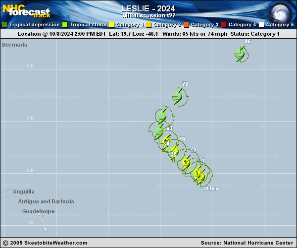
Copy of official data Hurricane Leslie Discussion Number 27 NWS National Hurricane Center Miami FL AL132024 1100 PM AST Tue Oct 08 2024 This evening, Leslie's structure has improved further as deep convection can be seen wrapping around the center on GOES-16 infrared imagery. An earlier ISS-COWVR microwave pass at 2021 UTC also showed a small inner-core eyewall feature. Subjective Dvorak fixes from TAFB and SAB were both T4.0/65-kt, but objective estimates from ADT and SATCON have jumped up to 79 and 74 kt respectively, and thus the initial intensity is raised to 70 kt, in between the subjective and objective estimates. One thing that hasn't changed is Leslie's current motion, still off to the northwest at 310/10 kt. Over the next couple of days, Leslie will be approaching the westward extent of the subtropical ridge that has been its primary steering mechanism, resulting in a gradual slow down and turn northward by the end of this week. Leslie is then expected to be captured by an approaching long-wave trough, leading to a northeastward motion by the end of the forecast period. The NHC track continues to be in good agreement with the track guidance, and is just a touch west compared to the prior forecast. Leslie's intensity prospects in the short-term have undergone a reversal from yesterday. The shear that had been affecting the hurricane has subsided, and SHIPS guidance now shows deep-layer shear reaming under 10 kt for at least the next 24 hours. Even though Leslie has been traveling over a cooler ocean left behind from Kirk last week, the sea-surface temperatures still appear to be warm enough (27-28 C) to promote intensification, as evidence of its continued deep convective bursts which have helped reform its inner core. The intensity guidance has responded to these changes by now showing more intensification. In fact, the raw 18 UTC HAFS-A/B runs now show intensification up to 80-85 kt in 36 hours. In addition, the latest ECMWF run, not usually known for being at the upper-end of the intensity guidance, shows significant deepening in the short-term, with a forecast pressure down to 969 mb by early Thursday morning. Based on these signals, the intensity guidance was raised upward significantly in the short term, and now shows Leslie peaking as an 80 kt hurricane in 24-36 hours. After that time, a large upper-level anticyclone approaching from the northwest (partially related to outflow from both AL93 and Milton) should lead to an abrupt increase in northerly shear. Thus, rapid weakening is still anticipated beyond that time, and Leslie still appears likely to become a post-tropical cyclone in about 3 days, as its convection is stripped away by the shear. The intensity forecast is on the upper-end of the guidance over the first 36 h, but falls back to the guidance mean by the end of the forecast period. FORECAST POSITIONS AND MAX WINDS INIT 09/0300Z 20.7N 47.0W 70 KT 80 MPH 12H 09/1200Z 21.7N 48.0W 75 KT 85 MPH 24H 10/0000Z 22.7N 49.0W 80 KT 90 MPH 36H 10/1200Z 23.6N 49.7W 80 KT 90 MPH 48H 11/0000Z 24.8N 49.9W 60 KT 70 MPH 60H 11/1200Z 26.6N 49.1W 45 KT 50 MPH 72H 12/0000Z 29.0N 47.0W 40 KT 45 MPH...POST-TROPICAL 96H 13/0000Z 33.0N 39.5W 35 KT 40 MPH...POST-TROPICAL 120H 14/0000Z 35.1N 32.0W 30 KT 35 MPH...POST-TROP/REMNT LOW $$ Forecaster Papin |